Leidsid 33 sarnast õppematerjali, mis on seotud failiga "Alaska". Need materjalid aitavad sul teemat sügavamalt mõista.
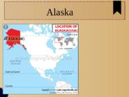
alaska, yukon, arctic, ocean, british, columbia, 20th, century, highest, lowest, different, mammal, bird, species, lakes, rivers, trail, border, foot, thanks2011 Table of Contents 1.Alaska info...................................3.lk 2.Geography.....................................4.lk 3.Natural features......................5.lk 4.Climate...........................................6.lk 5.Pictures.........................................7.lk 6.Used Sources..............................8.lk Alaska info Alaska is the largest state in the United States by area. It is situated in the northwest extremity of the North American continent, with Canada to the east, the Arctic Ocean to the north, and the Pacific Ocean to the west and south, with Russia further west across the Bering Strait. Alaska is the least densely populated state of the U.S. 2 Alaska was purchased from Russia on March 30, 1867, for $7.2 million at approximately two cents per acre
Alaska General information Area 1,717,854 km² (1st) Capital Juneau Population - 731,449 (47th) Native people Numerous tribes The Inuit people (eskimos) The Aleut people The Alutiiq people Colonisation Russians - 17th century Name origin Alaska (Russian) Alakshak (Aleutan) Peninsula Nicknames The Last Frontier Land of the Midnight Sun State of Alaska 1959 Symbols Flag - Seal - Symbols 2 Bird - Willow Ptarmigan Dog - Alaskan Malamute Sport Dog Mushing Head of state Governor Sean Parnell (2009..) Republican Geography Coastline 800km East Canada West the Bering Sea North Arctic Ocean South Pacific Ocean Mountains 50 peaks higher than 3.6km Mount McKinley 6.2km Mount Saint Elias 5.5km
Area: Total 9,826,630 km2 (by CIA World Factbook) Currency: United States dollar ($) Motto: In God We Trust Anthem: "The Star-Spangled Banner" Flag Names: The Stars and Stripes, Old Glory, The Starry Banner Seal: Great Seal of the United States Flag Seal Geography America consists of 50 states. 48 of them are on North American continent and 2 of them (Alaska and Hawaii) are separated. Alaska is separated by Canada and Hawaii lies in the Pacific Ocean. America shares borders with Canada, Mexico and Russia. According to different sources American landmass is from 9,522,055 km2 to 9,826,630 km2 which makes it the third or fourth largest country in the world. America is surrounded by three oceans Pacific Ocean, Atlantic Ocean and Arctic Ocean. It's also bounded with Gulf of Mexico and Bering Strait. The highest point in America is Mount McKinley (6,194 m) in Alaska
The U.S. economy is the world's largest national economy Click to edit Master text styles Second level Third level Fourth level Fifth level Nature America consists of 50 states. 48 of them are on North American continent and 2 of them (Alaska and Hawaii) are separated. Alaska is separated by Canada and Hawaii lies in the Pacific Ocean. America shares borders with Canada, Mexico and Russia. America is surrounded by three oceans Pacific Ocean, Atlantic Ocean and Arctic Ocean. It's also bounded with Gulf of Mexico and Bering Strait. The highest point in America is Mount McKinley (6,194 m) in Alaska. The lowest point is Death Valley which lies 86 metres below sea level. The Great Basin Desert is the largest desert in America. Missouri river is the longest river in the States. The largest lake is Lake Superior.
Canada. Canada is a very big country in the continent of North America. It is about 10 million square kilometres and that makes it the second largest country in the world after Russia. Quebec (the province) is six times as big as the UK. Canada borders the Atlantic Ocean, the Pacific Ocean, the Arctic Ocean and the USA. The capital of Canada is Ottawa and other main cities are Toronto, Montreal and Vancouver. It is a very developed country. Montreal is the largest city and it is called the Paris of North America because most of the people there speak French. The population of Canada is 28 million people. It is a very multicultural country. People from many different countries have come to live there. The natives are Eskimos and Indians. Eskimos have their own self-governing homeland called
across the country, Canadians experience many different landscapes from rolling plains and mountains to the cold tundra of the north. Despite Canada's great size, it is one of the world's most sparsely populated countries. This fact, coupled with the grandeur of the landscape, has been central to the sense of Canadian national identity. 2. Geographical position Canada is the second largest country in the world after Russia. In the Arctic, Canada reaches almost as far north as Greenland. To the south it extends to the same latitude as southern France. The distance from Canada's west coast, the Pacific Ocean, to its east coast, the Atlantic Ocean, is farther than from North America to Europe. Canada's total land area includes thousands of adjacent islands, notably Newfoundland in the east and those of the Arctic Archipelago in the north. In longitude Canada extends from approximately 52° to 141° W, a distance that spans
C. Other big and famous cities are New York, Los Angeles, Houston, Chicago and Las Vegas. The national anthem of the United States is "The Star-Spangled Banner", with lyrics written in 1814 by Francis Scott Key. There are 6 time zones. From east to west they are: Eastern Standard Time, which is 5 hours behind Greenwich Time, Central Standard Time, Mountain Standard Time, which is 7 hours behind Greenwich Time, Pacific Standard Time. Alaska and Hawaii have their own time zones: Alaska Standard Time and Hawaii Standard Time. Geographical Position The USA lies in the Northern Hemisphere in North America. It covers a big part of the continent and is also the third largest country in the world. The country consists of 50 states, but two of them lie separately. One of them is Alaska, which is near the Arctic Circle. And the other state is Hawaii, which is a group of island is the Pacific Ocean. The USA shares the border with Canada in the north and Mexico in the south
Topic Canada Tallinn English College 2006 1. Introduction If you had to use two words to describe Canada, they might be large and diverse. Canada is the second largest country in the world with a territory of about 10 million square kilometers and it is bordered by three oceans: the Arctic, the Pacific and the Atlantic Oceans. The population of Canada is about 31 million people. About 77% of the people live in cities which lie in a band about 100 miles wide above the border of the United States. The capital of Canada is Ottawa. Other large cities are Montreal, Toronto, Vancouver, Winnipeg and Quebec. 2. Geographical position Canada is a huge country in the continent of North America. It is bordered with the Atlantic
2010 Canada, Kärt Kalvet 8a Canada General Information Canada is in North America. It's area is 9220970 sq km. Canada's population is 313.612.000 people. Canada is divided into 10 provinces and 3 territories. The capital of Canada is Ottawa. Canada has constitutional monarchy. The head of state in Canada's government is the Queen of England. There are two main languages in Canada: English and French. Canada's curreny is Canadian dollar (1 dollar=100 cents[Can$]). The highest peak of Canada is Mount Logan, 5959 metres. The lowest point is sea level. The longest river is the Mackenzie. The climate and geography of Canada vary greatly from temperate in the south to arctic in the north and from islands and plains in the east to mountains in the west. Location Canada is located in the northern-most region of North America. It's geographical position in co- ordinates is 83°N north, 42°N south, 53°W east, 141°W west. Canada borders with United States
Territory and landscape Canada is one of the largest countries in the world. It covers nearly 4 million square miles. It is dividend into ten provinces( British Columbia, Manitoba, New Brunswick, Alberta, Nova Scotia, Ontario, Prince Edward Island, Quebec, Saskatchewan, Newfoundland ) along with two territories( the Yukon, the Northwest territories ). The capital city is Ottawa. Canada is a country rich in forests. It borders in the south with The United States and it's surrounded in the west by the Pacific Ocean, in the east by the Atlantic Ocean and above by many smaller bays, but is also borderedd with Alaska in the north-west. To the north of Canada is the broad Canadian Shield, an area of rock scoured clean by the last ice age, thinly soiled, rich in minerals, and dotted with lakes and rivers
The United States of America is a very big country. Its territory is about 9.4 million square kilometres and its population is more than 260 million people, 12% of them are the Afro-Americans. It is the world's third-largest country by size and by population. The population density is about 27 people per square kilometre. Most of the people live in towns. There are 50 states in America. The biggest of the state is Texas, next by size are California, Alaska and Montana. Six states - Maine, Vermont, New Hampshire, Connecticut ,Rhode Island and Massachusetts are called New England. They are all small states in the U.S. that lie in the north-east. The first colony of immigrants settled down in Virginia, in the eastern part of the U.S.A. The biggest cities are New York, Washington, Chicago, Los Angeles, San Francisco, etc. The flag of America was adopted on 14 th June 1777. It is called the "Stars and Stripes"
language. English is the most common language for daily interaction among both native and non-native speakers. Spanish is the second language. The largest city is the New York City. The Government is Federal constitutional republic and the president is George W. Bush. 2. Geographical position The United States of America is located on the continent of North America. It has borders with two countries Mexico and Canada. There are also the Atlantic Ocean, the Pacific Ocean and the Gulf of Mexico surrounding the big country. There are 50 states in America. Most of the people live in towns. The biggest state is Alaska; next by size are California, Alaska and Montana. Six states - Maine, Vermont, New Hampshire, Connecticut, Rhode Island and Massachusetts are called New England. They are all small states in the USA that lie in the north- east. The first colony of immigrants settled down in Virginia, in the eastern part of the USA. 3. Relief
The United States of America (The U.S.A) Geography The main part of the United states extends from the Atlantic Ocean in the east to the Pacific Ocean in the west. It covers the middle of the North American continent. This area is called ,,the continental United states". The continental United States is bounded to the North by Canada and to the South by Mexico. The border with Canada is often called ,,the longest unguarded border in the world". The United States and Canada are good friends and they have very few problems in managing the border. The borded with Mexico is different. Immigrants are constantly crossing the border illegally
CANADA Canada is a vast country, second largest country of the world after Russia. It stretches from the Atlantic Ocean in the east to the Pacific Ocean in the west and to the Arctic Ocean in the North. Canada Covers most of the northern part of North America and its geography is very diverse. Canada's area is about 10 million square kilometers and its population is 31 000 000. Its capital is Ottowa and other main cities are Toronto, Montreal and Vancouver. Almost 75 % of canadians lives within 300 kilometer of the USA border, because the climate is softer in the South. 89 % of Canada is almost unhabited.
10 million square kilometres, but is one of the most sparsely populated, with only about 34 million inhabitants. The majority of them live within 300 kilometres of Canada's southern border. Much of the rest of Canada is uninhabited or thinly populated, because the country has a rugged terrain and severe climate. Canada extends across the continent of North America, from Newfoundland on the Atlantic coast to British Columbia on the Pacific coast and northward into the Arctic Ocean. Canada shares land borders with the United States to the south and north-west. Canada is a land of great variety. Towering mountains, crystal-clear lakes, and lush, green forests make Canada's far west a beautiful region. Farther inland, fields of wheat and other grains cover Canada's vast prairies. Thes fertile farmlands contrast vividly with the Arctic wastelands to the north. Most of the largest towns and industrial areas lie near the Great Lakes and the St
Tallinn English College CANADA Report Karin Kristen Tapupere 8.b Instructor: Tiiu Martma Intro: Canada is a country occupying most of northern North America, extending from the Atlantic Ocean in the east to the Pacific Ocean in the west and northward into the Arctic Ocean. It is the world's second largest country by total area and its common border with the United States to the south and northwest is the longest in the world. The land occupied by Canada was inhabited for millennia by various groups of Aboriginal people. Beginning in the late 15th century, British and French expeditions explored, and later settled along, the Atlantic coast. France ceded nearly all of its colonies in North America in 1763 after the Seven Years' War. In 1867, with the
Tallinna Inglise Kolledz Canada. The land of diversity. Tallinn 2006 Canada. If you had to use two words to describe Canada, they might be large and diverse. Canada is the second largest country in the world with a territory of about 10 million square kilometers and it is bordered by three oceans: the Arctic, the Pacific and the Atlantic Oceans. The population of Canada is about 31 million people. About 77% of the people live in cities which lie in a band about 100 miles wide above the border of the United States. The capital of Canada is Ottawa. Other large cities are Montreal, Toronto, Vancouver, Winnipeg and Quebec. Canada has two official languages English and French. It's interesting to know that about 61% of Canadians name English and 24% French their mother tongue
The United States of America Geography The United States of America is situated in the central part of the North American continent. Its western coast is washed by the Pacific Ocean, and its eastern coast by the Atlantic Ocean and the Gulf of Mexico. It borders on Canada in the north and on Mexico in the South. The U.S.A. consists of 51 states and the District of Columbia. The state of Alaska is separated from the rest of the U.S.A. by Canada. Hawaii, which became the fiftieth state in 1959, is in the Pacific Ocean, halfway between the continents of America and Asia. The area of the United States of America is over nine million square kilometres. The continental part of the U.S.A. consists of two highland regions and two lowland regions. The highland regions are the Appalachian Mountains in the east and the Cordilleras in the west. The
Topic Canada History The first people to live in what is now Canada arrive from Asia at least 20 000 years ago. They arrived by a way of a land bridge that once connected Asia and North America at what is now Alaska. In 1497, John Capot, an Italian navigator in the service of England found rich fishing grounds off Canada's southeast coast. France took the lead in exploring the country and set up a colony in eastern Canada in the early 1600's. Great Britain gained control of the country in 1763 and thousands of British immigrants began to join the French who remained in Canada. Canada gained its independence from Britain in 1931. Position/area Canada is the second largest country in the world
Usa 1. Gross Domestic Products Gross Domestic Products of USA United States of America has the highest Gross Domestic Products nominal about 14.624 trillion US dollars according to World Bank. 2. Rhode Island Rhode Island is actually named Rhode Island and Providence Plantations and it makes the smallest state in the United States has the longest name. 3. Califrnia never rains It is believed that California is the state with the lowest rainfall in the world. For two years, California never rains. For those amazing and unique facts, California has been attracting so many tourists. Many people also adore this fact and this facts is often included in a song lyric. 4. President Grover Cleveland Grover Cleveland is the only USA president who married in office. It becomes more unusual because he married 21 years old bride when he was 49. 5. National Holidays There are ten official national holidays in the United States
The United States of America is a very big country. Its territory is about 9.4 million square kilometres and its population is more than 260 million people, 12% of them are the Afro-Americans. It is the world's third-largest country by size and by population. The population density is about 27 people per square kilometre. Most of the people live in towns. There are 50 states in America. The biggest of the state is Texas, next by size are California, Alaska and Montana. Six states - Maine, Vermont, New Hampshire, Connecticut ,Rhode Island and Massachusetts are called New England. They are all small states in the U.S. that lie in the north-east. The first colony of immigrants settled down in Virginia, in the eastern part of the U.S.A. The biggest cities are New York, Washington, Chicago, Los Angeles, San Francisco, etc. The official language of the USA is English; Spanish is also widely spoken. The currency of the USA is the United States Dollar.
Insect-Baltimore checkerspot butterfly Reptile-Diamondback terrapin SYMBOLS Song-"Maryland! My Maryland!" Sport-Jousting Team sport-Lacrosse Tree- White oak Cat- Calico Crustacean- Maryland blue crab Motto- Fatti maschil, Parole femine (loosely translated as "Manly deeds, Womanly words" GEOGRAPHY 250 miles long 90 miles wide Border States: Regional List, Delaware,Pennsylvania Virginia ,West Virginia Highest point: Hoye-Crest on Backbone Mountain Lowest point: Sea level at the Atlantic Ocean Major Rivers: Patapsco River, Patuxent River, Potomac River, Susquehanna River. Major Lakes:Deep Creek Lake, Loch Raven Reservoir, Prettyboy Reservoir. CLIMATE Wide array of climates Vulnerable to tropical cyclones 89110 mm per month of rain 23 cm to over 250 cm snow Average temperature 14,75°C 3040 days of thunderstorms a year
nationalities. Besides English and French there are also immigrants from Scotland, Ireland, Wales, Germany, Ukraine and Scandinavia. In Edmonton and Calgary there are also historic Chinatowns, and Calgary has Canada's third largest Chinese community. Geographical features Alberta covers an area of 661,848 square kilometres, an area about 5% smaller than Texas or 20% larger than France. This makes it the fourth largest province after Quebec, Ontario, and British Columbia. To the south, the province borders on the 49th parallel north, separating it from the U.S. state of Montana, while on the north the 60th parallel north divides it from the Northwest Territories. To the east the 110th meridian west separates it from the province of Saskatchewan, while on the west its boundary with British Columbia follows the 120th meridian west south from the Northwest Territories at 60°N until it reaches the Continental Divide at the Rocky Mountains.
Technical English, Scientific English, English for medical professionals, English for waiters, English for tourism, English for Art Purposes, etc 4. What is the difference between settlement colonies and the trading empire (dependencies)? Settlement colonies were regions colonized by the UK that later established governments and became dominions and independent. Dependencies were regions in the world that became trading partners and where English became a second language. 5. Which British colonies became dominions? What was their status? Is the name dominion used for these countries nowadays? The first dominions were Canada (1867), Australia (1901), and New Zealand (1907) The name "dominion" is not used anymore. 6. Which organisation unites Britain and most of its former colonies nowadays? The Commonwealth unites Britain with its former colonies. Ireland 1. Who were the early inhabitants of Ireland?
Revolutionary War. In 1775, the Continental Congress, convening in Philadelphia, established a Continental Army under the command of George Washington. Proclaiming that "all men are created equal" and endowed with "certain unalienable Rights," the Congress adopted the Declaration of Independence, drafted largely by Thomas Jefferson, on July 4, 1776. That date is now celebrated annually as America's Independence Day. After the American forces had defeated British forces the Independence of the United States was announced. George Washington was the first president of the United States of America. In World War I America tryed to be neutral but still joined the Allies forces which won the war. USA has always been one of the most liberate country in the world and there has always been democracy. In World War II USA was again on the winners side and after that the Cold War started which was won again
Topic The USA The USA is situated in the central part of the North American continent. Its western coast is washed by the Pacific Ocean and its eastern coast by the Atlantic Ocean an the Gulf of Mexico. It borders on Canada in the north and on Mexico in the south. The USA consists of fifty-one states and the District of Columbia. The state of Alaska is separated from the rest of the USA by Canada. Hawaii, which became the fiftieth state in 1959, is in the Pacific Ocean, halfway between the continents of America and Asia. The USA is one of the largest countries in the world. Its area is over 9 million square kilometers. Symbols of the United States include the American flag and the Great Seal. The name, "United States Of America", is usually shortened to "The United States", "America", or simply "The US" or "USA".
Inuit Culture, Traditions, and History Traditional Inuit way of life was influenced by the harsh climate and stark landscapes of the Arctic tundra from beliefs inspired by stories of the aurora to practicalities like homes made of snow. Inuit invented tools, gear, and methods to help them survive in this environment. Read on to learn more about traditional Inuit ways of life, and how Inuit culture has been changed over the past century. Geography Inuit communities are found in the Arctic, in the Northwest Territories, Labrador and Quebec in Canada, above tree line in Alaska (where people are called the Inupiat and Yupik), and in Russia (where people are called the Yupik people). In some areas, Inuit people are called "Eskimos" however many Inuit find this term offensive. The word "Inuit" means "the people" in the Inuktitut language. Inuit Homes In the tundra, where Inuit communities are found, there are not many building materials. No trees
The 50 small, white stars represent the 50 U.S. states. The U.S. flag is commonly called ,,the Stars and Stripes". The Statue of Liberty, that is locatd in New York,is a gift from the France. The Libety Bell, that is a bronze bell that symbolizes freedom in the United States of America. It is located in Pennsylvania,U.S. Capital: Washington D.C Biggest city: New York National language: English Location U.S is located in North America, bordering both the North Atlantic Ocean and the North Pacific Ocean. United States neighbour countries are Canada and Mexico. The USA has the 8th longest coastline in the world at ~20 000 km. 62% of the perimeter of the USA is coastline. The USA's coastline is made up of beaches, cliffs, mangroves, and urban and developed areas, which make America very versatile country. Political division United States of America distributes into 50 states. The government power is limited by a dual
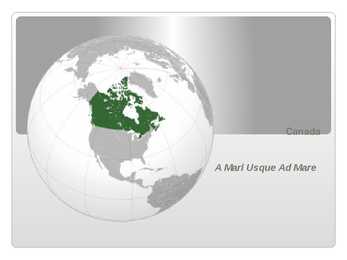
Canada A Mari Usque Ad Mare Official language(s) English, French Inuktitut, Inuinnaqtun, Cree, Recognised regional languages Dëne Sliné, Gwich'in, Inuvialuktun, Slavey, Tlch Yatiì Languages in Canada North American country consisting of ten provinces and three territories located in the northern part of the continent, it extends from the Atlantic Ocean in the east to the Pacific Ocean in the west, and northward into the Arctic Ocean spanning over 9.9 million square kilometers, Canada is the world's second largest country by total area its common border with the United States is the longest land border in the world. Some facts The land that is now Canada was inhabited for millennia by various groups of Aboriginal peoples beginning in the late 15th century, British and French
Topic The United States of America The U.S.A. is situated in the central part of the North American continent. The area of the U.S.A. is over nine million square kilometres. Its western coast is washed by Pacific Ocean and its eastern coast by the Atlantic ocean and the Gulf of Mexico. The continental United States is bounded to the North by Canada and to the South by Mexico. There are two mountain ranges in the continental United States: the Appalachians in the east and the Rockies in the west. In the very middle of the continent is the Mississippi river. The five Great lakes, between the U.S.A. and Canada, are joined together by short rivers or canals. They are connected with the Atlantic Ocean by the St.
CANADA REVISION QUESTIONS 2010 1. The main physiographic regions of Canada. Canada may be divided into seven physiographic regions: Arctic Lowlands, Cordilleran Region, Interior Plains, Hudson Bay Lowlands, Canadian Shield (Forest Lands), St Lawrence Lowlands and Appalachian Region. Divisions are based on each area's relatively similar physical geography and landforms. Physiographic regionalization is defined here as the process by which regions with relatively homogeneous physical geography are determined 2. Who are the native people of Canada? Into which three groups can they be divided?
Gobi Asia 500,000 Libya n Africa 450,000 Sono ran No rt h Ameri ca 120,000 Oceans Arct ic Ocean Atlantic Ocean Area: 5,426 ,000 sq. mi . Area: 3 1,73 6,000 sq . mi . Coastline: 28 ,209 mi . Coastl ine: 69 ,525 m i. Average De p t h: 3,407 ft. Average De p t h: 11,730 ft.
equator. Sometimes Australia is called the island continent. There is a great reason why. It really is an island. It is 2880 km from the mainland of Asia and is almost half way round the world from Europe. More than 9 600 km separates it from America. Australia lies between the Pacific and Indian oceans. The Timor Sea and the Arafura Sea separate Australia from Indonesia. In the north the coast is washed by Great Australian Bight and the Indian Ocean. In the northeast the Coral Sea washes the coasts and in the southeast there is the Tasman Sea which also separates Australia from New Zealand. The biggest island is Tasmania which is located to the south of the country. 3 Relief Australia is a flat and old continent. Its average height is 274 m above sea level. Its relief is pretty simple – plains cover the greater part of it. Basically one third of its area is covered by deserts and