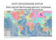
436 pp. Fig. 159. Isolines of the bedrock topography, drawn after 20 m. Raukas, A., Teedumäe, A. (eds). 1997. Geology and Mineral Resources of Estonia. Estonian Academy Publishers, Tallinn. 436 pp. Fig. 160. Zonation of the bedrock topography (after Tavast 1992): 1 - boundaries of large bedrock forms; 2 - boundaries of medium bedrock forms; 3 - escarpments. I - Depression of the Gulf of Finland: 1 - Sub-Vendian Peneplain; 2 - Cambrian-Vendian Peneplain; 3 - Vendian Escarpment; 4 - Cambrian Escarpment. II - Viru-Harju Plateau: 1 - Ordovician Escarpment; 2 - Pandivere Elevation; 3 - Ahtme Eminence. III - Livonian Lowland: 1 - West-Estonian Lowland; 2 - Depression of the Gulf of Riga. IV - Middle-Devonian Plateau: 1 - South- Sakala Elevation; 2 - Otepää Elevation; 3 - North-Vidzeme Depression. V - Central-Estonian Lowland and Depression of Lake Võrtsjärv. VI - Lake Peipsi Depression. VII - Valga and South-Estonian lowlands. VIII - Upper-
The Chiltern Hills Ursula 11. kl · The Chiltern Hills are known locally as just The Chilterns and are a chalk escarpment in the south-east of England, lying a few miles north-west of London. · They cover four counties and combine beautiful scenery with interesting history. · The Chilterns begin in Oxfordshire in the Thames Valley and stretch north-east through Buckinghamshire and Bedfordshire to Hitchin in Hertfordshire. They comprise of chalk hills covered with beautiful beech woods, wild flowers, and a variety of wildlife. History
Mozambique. At 587,000 square kilometres, Madagascar is the world's 46th-largest country and the fourth- largest island. Madagascar can be divided into five geographical regions: the east coast, the Tsaratanana Massif, the central highlands, the west coast, and the southwest. The east coast The east coast consists of a narrow band of lowlands, formed from the sedimentation of alluvial soils and zone, composed of steep bluffs, alternating with ravines bordering an escarpment of about 500 meters in elevation. The coastline is straight, with the exception of the bay. The east coast is considered dangerous for swimmers and sailors because of the large number of sharks that frequent the shoreline. The Tsaratanana Massif region The island's highest peak, Maromokotro, at 2,876 metres is found in the Tsaratanana Massif, located in the far north of the country. The coastline is deeply indented; two prominent features are the excellent natural harbor at
Throughout the greater part of our independent statehood both the Estonian Parliament and the Government have worked here, but in summer 2000 the Government moved to the Stenbock House According to an old legend, the hill of Toompea was heaped up, stone by stone, by Linda, in mourning for her husband Kalev. The earliest buildings confirmed by historical data originate from the 9th century when ancient Estonians took advantage of the steep escarpment of Toompea and erected here their ancient stronghold of Lindanisa, one of the best-protected strongholds in Estonia. A settlement of tradesmen and artisans began to develop at the foot of Toompea hill. Farmers from the neighbouring counties, mainly from Rävala County, were the masters of Toompea stronghold and used it only in the event of danger. This also explains how in 1219 King Valdemar II of Denmark conquered the stronghold with ease. From that time on the stronghold of Toompea, and
5 m) kaudu. Tänu suurele vooluhulgale ei ole Hoburaua joa all rusu ning juga langeb otse vette. Ameerika ning Pruudiloori joa vool ei ole piisavalt tugev varisenud kivide eemaldamiseks ning nii on mõlema joa alla kuhjunud rusu. Vabalt langeb vesi umbes pool joa kogukõrgusest. Geoloogiline ehitus ja ajalugu Joa astang on osa Niagara astangust (Niagara Escarpment), klindinõlvast, mis ulatub Ontario järvest idas Michigani järve läänekaldale.Astangu pealmise kõvema kihi moodustavad Kesk-Siluri Lockporti dolomiidid, mille all asuvad pehmemad Alam-Siluri kiltkivid. Jääaja (Wisconsini jäätumise) lõppedes 10 000 aastat tagasi asus juga Niagara astangu joonel Ontario järve lõunakalda lähedal. Järgnevate aastatuhandete jooksul on vesi astangut 11 km lõuna poole uuristanud keskmise kiirusega 12 m aastas. Kitsesaareni, kus eraldusid
Since the 1980's a number of beautiful and sometimes curious caves have been found in this area and reports on them have appeared in various publications Qasr Zabal at Sakakah. Words 1. Shrub-puhmas 2. Adaptation-mugandus, kohandamine 3. Aridity-kõrbekuivus 4. interior-sisemine 5. plateau-platoo 6. fertile-viljakas 7. deciduous-pudenev 8. low-lying-madalal asuv 9. plain-tsandik 10. bound-suunduv 11. escarpment-astang 12. realm-kuningriik 13. mean-kekmine 14. stem-vars 15. toad-kärnkonn 16. semiarid-poolkõrbeline 17. hazardous-ohtlik 18. glossy-läikiv 19. radiant-särav 20. unfavourable-ebasoodus 21. odor-lõhn 22. burrow-urg 23. nocturnal-öine 24. arachnid-ämblikulaadne 25. humidity-niiskus References · http://www.ucmp.berkeley.edu/exhibits/biomes/deserts.php · http://en.wikipedia.org/wiki/Desert · http://www.blueplanetbiomes.org/desert.htm · http://encarta
It is the birthplace of internationally acclaimed singers, music bands, authors, artists and sculptors. Perth is the capital of the Australian state of Western Australia. A population of 1,477,800 makes Perth the largest city in Western Australia and home to threequarters of the state's residents. The city is also the fourth most populous urban area in Australia. The metropolitan area is located in the south west of the continent between the Indian Ocean and a low coastal escarpment known as the Darling Range. The central business district and suburbs of Perth are situated on the Swan River. Founded in 1829 by Captain James Stirling as the political centre of the free settler Swan River Colony, Perth has continued to serve as the seat of Government for Western Australia to the present day. Traditionally, Perth and the Swan River have usually been viewed and photographed