Irish Protestants Green- Irish Catholics White- peace Ireland No snakes in Ireland Wales Llanfairpwllgwyngyllgogerychwyrndrobwllllantysiliogogogoch Click to edit Master text styles Second level Third level Fourth level Fifth level New Zealand The southernmost capital. 11 sheep per citizen . England Shortest war in 1896 Less than 38 minutes Scotland Scotland prints its own banknotes which are accepted all over the UK The Usa Alaskan purchase check Canada The largest Island in Canada is Baffin Island Australia Wave Rock http://www.ireland-information.com/articles/titanicandireland.htm http://www.ireland-information.com/articles/titanicandireland.htm http://
Earthquake Summer~winter Legend Fished from the sea Youngest country The Maori The Maori AotearoaLand of the Long White Cloud Farming and hunting By 1,800 about 100,000 Maori European Migration Abel Tasman 1642 He never set foot on New Zealand 1840 treaty was signed Colony of Britain Whalers and missionaires Interesting facts 9 sheep to every 1 human Wellington is the southernmost capital city in the world Last major landmass to be populated A kiwi Famous people Ernest Rutherfordfather of nuclear physics for his orbital theory of the atom Sir Edmund Hillary Russell Crowe Thank You for listening! http://listverse.com/2008/06/19/top20coolfact http://www.newzealand.com/ http://en.wikipedia.org/wiki/New_Zealand
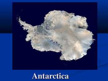
Antarctica Antarctica is Earth's southernmost continent, overlying the South Pole. It is situated in the southern hemisphere, almost entirely south of the Antarctic Circle, and is surrounded by the Southern Ocean. Antarctica area is 14,000,000 km² , icefree area is about 280,000 km² and icecovered is about 13,720,000 km² that means about 98% of Antarctica is covered by ice. Climate of Antarctica Antarctica is the coldest, driest and windiest continent, and has the highest average elevation of all the continents. The coldest natural temperature ever recorded on Earth was -89.2 °C at the Russian Vostok Station in Antarctica on 21 July 1983. Antarctica is also extremely dry, technically a desert, whit an average of only 166 mm of precipitation per year. Population of Antarctica The number of people conducting and supporting scientific research. The number of ...
Castle, St Fagans Old Rectory and St Mary's Church. In 1648, the Battle of St Fagans took place close by. Chepstow Castle Chepstow Castle, located in Chepstow, Monmouthshire in Wales, on top of cliffs overlooking the River Wye, is the oldest surviving post-Roman stone fortification in Britain. Its construction was begun under the instruction of the Norman Lord William fitzOsbern, soon made Earl of Hereford, from 1067, and it was the southernmost of a chain of castles built along the English-Welsh border in the Welsh Marches. The castle ruins are Grade I listed as at 6 December 1950 Chester castle In the City of Chester near the Racecourse and River, on the border with Wales. The remains of Chester castle stand on a low hill within a bend of the River Dee, just a stones-throw from the border with Wales. Although this once-mighty fortress has been obscured by newer
1,000 ships in the canal's early days to 14,702 vessels in 2008, measuring a total 309.6 million Panama Canal/Universal Measurement System (PC/UMS) tons. In total over 815,000 vessels have passed through the canal.One of the largest and most difficult engineering projects ever undertaken, the canal had an enormous impact on shipping between the two oceans, replacing the long and treacherous route via either the Strait of Magellan or Cape Horn at the southernmost tip of South America. A ship sailing from New York to San Francisco via the canal travels 9,500 km well under half the 22,500 km route around Cape Horn. Golden Gate Bridge Date started:January 5, 1933 Date finished:May 27, 1937 Location:Golden Gate Strait, north of San Francisco, California, U.S. The Golden Gate Bridge is a suspension bridge spanning the Golden Gate, the opening of the San Francisco Bay into the Pacific Ocean. As part of both U.S
justly a top tourist destination for its staggering beauty. With sand dunes reminiscent of a desert landscape, it stretches from just west of Kaitaia right to Cape Reinga, the northernmost tip of New Zealand. Golden sands and impressive breakers alongside the magical Aupouri Forest make this perhaps the most famous beach in New Zealand -- it's certainly the biggest. The long stretch of beach is best accessed from Ahipara township at the southernmost point of the beach. Follow Sandhill Road north with various access points dotted along the way.
......... 9 SUMMARY WAVE ENERGY VARIATION IN THE FIELD OF STUDY Kristina Samoshenkova Long-term average power of waves per unit length of one of the modeled shoreline varies significantly along the eastern Baltic Sea region (Figure 5). Lithuania and the Russian part of the Curonian Spit has been retained by a public body wave energy flux uniformly average of 1.5-2 kW / m. The same situation is also characterized by a wave of energy flow along the Lithuanian coast. Latvian coast is the southernmost part of the average values of 1-1.5 kW / m. SISSEJUHATUS Pikaajaline lainete keskmine võimsus ühe pikkusühiku kohta modelleeritud rannajoonel varieerub olulisel määral piki Läänemere idaosa (joonis 5). Leedu ja osaliselt Venemaa haldusalasse jääval Kura säärel on laineenergia keskmine voog ühtlaselt 1,5−2 kW/m. Samasugune olukord iseloomustab ka laineenergia voogu piki Leedu rannikut. Läti ranniku lõunapoolsemas osas on keskmised väärtused 1−1,5 kW/m. 1
It is rich in hills, lakes (170) and valleys. The biggest city in South Estonia is Tartu, one of the oldest towns in the Baltic area. It is the second largest town in Estonia. It lies about 190 km southeast of Tallinn. It is the seat for Tartu University and is generally known as a university town. The centre lies between the two most important landmarks in Tartu: Toome hill and Emajõgi. Viljandi is a beautiful, quiet garden town submerged in greenery. Valga, Estonia's southernmost town lives and works hand in hand with Latvian Valka the border splits the town in two belonging to different coutries. Otepää is the skiing and winter capital of Estonia, as the area has more snow than any other part of Estonia. WEST ESTONIA West Estonia is low lying and flat. The climate is maritime and greatly influenced by the Baltic Sea. The area features large bogs, extensive forests, coastal plains and a number of offshore islands Saaremaa and Hiiumaa
Newfoundland in the east and those of the Arctic Archipelago in the north. In longitude Canada extends from approximately 52° to 141° W, a distance that spans six time zones. In latitude it extends from approximately 42° to 83° N. With its vast Arctic and subarctic territories, Canada is often considered a country only of the far north; however, the peninsula of southern Ontario juts deeply south into the heartland of the United States, and its southernmost point, Middle Island in Lake Erie, is at the same latitude as northern California. The country also includes several major islands, including Baffin, Ellesmere, Victoria, Newfoundland, and Melville, and many small ones. Its border with the U.S., the longest border in the world not patrolled by military forces, extends 8,890 km. 3. Mountains, lowlands Canada's vast area means it has many varying types of terrain, much of which is mountainous
Inland lakes cover almost 10 percent of the country`s entire area. None of Finland`s lakes are very deep, however; most of them averae around 100m (330ft). (www.wikipedia.org) Position and size Finland is made up of 11 provinces and the autonomous land Islands. It lies on the same latitude as Iceland, and one quarter of the country is inside the Artis Circle. Its northernmost point is at 70°5`, the southernmost at 59° 30` (on the same latitude as Oslo), the westerly point at 19°7`and the easternmost at 31°35` (on the same line of Longitude as Ankara). The country covers a total surface area of 338,000sq km (130,550sq miles), and its coastline is some 4,600km (2,760 miles) long. (Finland: Insight compact guides) 2 Climate The climate in Southern Finland is a northern temperate climate. In Northern Finland,
served as the national capital from the Federation of Australia until the construction of Canberra in 1927. Melbourne today is a major centre of commerce, industry and the arts. Often referred to as the "sporting capital of Australia" the city has a rich sporting history and is home to most of Australia's major annual sporting events. Melbourne is located in the southeastern corner of mainland Australia, and is the southernmost mainland capital city. Melbourne is typical of Australian capital cities in that it was built with the underlying notion of a "quarter acre home and garden" for every family, often referred to locally as the Australian Dream. The phrase "four seasons in a day" is part of popular culture and observed by many visitors to the city. Melbourne is a large commercial and industrial centre. Many of Australia's