Australia Australia is sometimes called the land " ..............." because it appears at the bottom of world maps. Aborigines had live in ................. for about 40, 000 years when Dutch ......... explorers reached it in the 17th century. The Dutch was ................ by Captain James Cook, exploring the .............. and southern coastlines in the ............ century. Today the population of ................. is more than 21 million. Australian .............. has it own accent and vocabulary, and it is the ............ language of the population. Sydney, with a ................. of 4 million, and ................... , with 3 million people, are the largest ............. in Australia. The beautiful building of the .............. Opera House is often seen in ........... and it has become one of the most .............
The crown on the shield is the crown of King Christian V. Tree: Beech, Flower: Red Clover Size - 43,075 km2 Population - 2011 estimate 5,564,219 Higest... - The Øresund or Öresund Bridge connects Sweden and Denmark, and it is the longest road and rail bridge in Europe. The highest point in the country is Mollehoj, at 170.86 m. Denmark shares a border of 68 kilometres with Germany. Denmark is a land of coastlines. No matter where you are in the country, the distance to the sea is short, and the chances of sea-views are pretty fair. Climate- The winters are not particularly cold, with mean temperatures in January and February of 0.0 °C, and the summers are cool, with a mean temperature in August of 15.7 °C. Denmark is famous for the little mermaid statue, football stadiums and art galleries. Denmark is also famous for the writer H.C. Andersen.
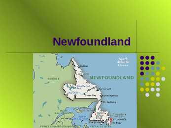
Labrador is a little smaller than California, slightly bigger than Japan, and twice the size of the entire United Kingdom. Geography The island of Newfoundland covers 111,390 square kilometres. With the addition of the vast territory of Labrador, the province covers a total area of 405,212 square kilometres, and has more than 29,000 kilometres of unspoiled coastline. Nature Newfoundland and Labrador is one of the best places to see nature in all its glory. Coastlines, thick forests, ancient rock formations, seabird colonies, tiny alpine blossoms, and rich marine life are all part of diverse natural heritage. Nature The provincial flower the pitcher plant can be found, among other wildflowers like rare orchids and plants, in bogs and marshland. Landscape holds, the most delightful just might be sweet, fresh berries(blueberries, partridgeberries, blackberries or crowberries) Bakeapples, also called cloudberries, are a local favourite.
Ireland Today Ireland has many political conflicts; many people have been killed in outbursts of violence Economic development Transport costs are high due to its location Low inflation and tax breaks attract foreign investors to the Republic The economy is heavily dependent on agriculture Tourism is a flourishing branch of the economy All the major cities lie on the coast or near the sea. They are Dublin, Galway, Limerick, Cork and Waterford Where to go? Ireland features wild coastlines, sandy beaches, lush valleys, dark peat lands and unruffled lakes. The island may be divided into the following parts: * Southeast Ireland * Cork and Kerry * the Lower Shannon * the West of Ireland * Northwest Ireland * the Midlands * Northern Ireland Southeast Ireland Kilkenny the country's loveliest inland city Kilkenny castle The Irish parliament often met in the castle in the 13th century. It was in the possession of the AngloNorman
by Guy Stewart Callendar. Solar activity Since 1978, output from the Sun has been precisely measured by satellites. These measurements indicate that the Sun's output has not increased since 1978, so the warming during the past 30 years cannot be attributed to an increase in solar energy reaching the Earth . The graphs show otherwise. Effects of global warming on oceans Global warming can affect sea levels, coastlines, ocean acidification, ocean currents, seawater, sea surface temperatures, tides, the sea floor, weather, and trigger several changes in ocean bio-geochemistry; all of these affect the functioning of a society. Impacts on society The rise in sea level along coastal regions carries implications for a wide range of habitats and inhabitants. Firstly, rising sea levels will have a serious impact on beaches— a place which humans love to visit recreationally and a prime location for real estate
88 in a hour) -34 emigrants average per day (-1.43 in a hour) The population of Nigeria will be increased by 9 496 persons daily in 2015. Nigeria population density Nigeria population density is 193.6 people per square kilometer as of October 2015. Density of population is calculated as permanently settled population of Nigeria divided by total area of the country. Total area is the sum of land and water areas within international boundaries and coastlines of Nigeria. The total area of Nigeria is 923 770 km2according to the United Nations Statistics Division . Nigeria age structure As of the beginning of 2015 according to our estimations Nigeria had the following population age distribution: 40.9 55.9 3.1 - percentage of population under 15 years old - percentage of population between 15 and 64 years old
The problem of ocean pollution affects every nation around the world. This is especially true because water is able to transport pollution from one location to another. For many years, chemicals were dumped into bodies of water without concern. While many countries have now banned such behavior, it continues to go on today. As the world has industrialized and its population has grown, the problem of water pollution has intensified. The simple fact that millions of people live along coastlines and near rivers means that these bodies of water are likely candidates for heavy and destructive pollution. It is hard to know now what our oceans will look like in the future. Just how damaged they will be by pollution is uncertain. Acid rain The term acid rain refers to what scientists call acid deposition. It is caused by airborne acidic pollutants and has highly destructive results. Scientists first discovered acid rain in 1852, when the English chemist Robert Agnus invented the term
Arizona and New Mexico. The Southwest area is rich in minerals. Cattle-breeding is also an important part of the Southwest's economy. The Rocky Mountain region includes the earth's youngest mountains. They have steep slopes and many peaks and picturesque valleys. The region isn't very populated. Most of the population is engaged in mining, cattle-breeding and farming. The Pacific Northwest and Alaska region is noted for its natural beauty: high steep mountains, forests and greatly indented coastlines. Portland and Seattle are important ports for trade with Asia. California and Hawaii. These two states are grouped together mainly because they are relatively near each other: California is the state which is situated nearer to Hawaii than any other state. They are not alike: California is one of the largest and most populated 5 states; Hawaii is one of the smallest and least populated ones. Yet there is one thing these
They are basically wind turbines that can be located anywhere there is strong tidal flow. Because water is about 800 times denser than air, tidal turbines will have to be much sturdier than wind turbines. They will be heavier and more expensive to build but will be able to capture more energy. 10.1 Wave Energy Waves are caused by the wind blowing over the surface of the ocean. There is tremendous energy in the ocean waves. The total power of waves breaking around the world's coastlines is estimated at 2-3 million megawatts. The west coasts of the US and Europe and the coasts of Japan and New Zealand are good sites for harnessing wave energy. One way to harness wave energy is to bend or focus the waves into a narrow channel, increasing their power and size. The waves can then be channeled into a catch basin or used directly to spin turbines. There are no big commercial wave energy plants, but there are a few small ones