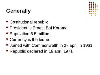
Tallinn English College Topic Estonia Tallinn 2008 1. Introduction Estonia is a small country about the size of Switzerland, or New Hampshire and Massachussetts combined. Estonia is named after the people called "Ests" who lived in the region in the 1 st century AD. The Republic of Estonia is one of the three countries commonly known as the "Baltic States". The other Baltic States are Latvia and Lithuania. 2. Geographical position Estonia is situated in northeastern Europe. Estonia is bounded on the north by the Gulf of Finland, on the east by Russia, on the south by Latvia and on the west by the Baltic Sea. In the north it borders on Finland. The coastline of the Baltic Sea in Estonia is characterized by numerous gulfs and bays, the biggest of them being the Gulf of Finland, the Gulf of Riga and the Gulf of Pärnu. Bays include the Narva Bay, Matsalu Bay, Kolga Bay, Kunda Bay, Tallinn Bay etc. Estonia has over 1500 islands, the largest being
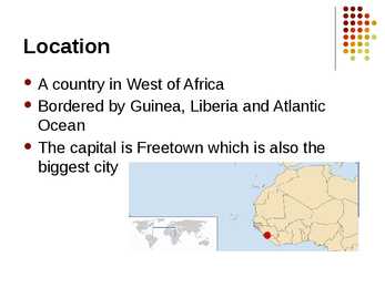
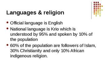
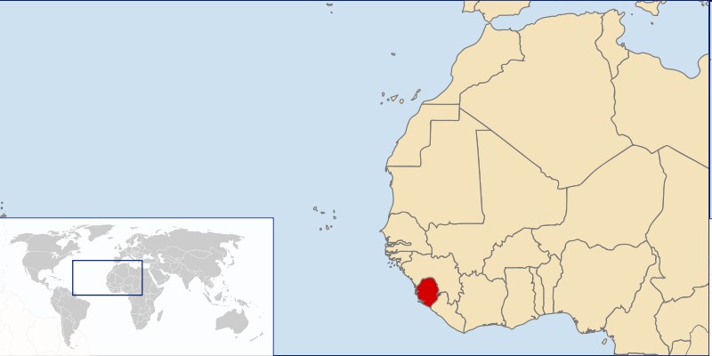
ancestry. This mixing happened relatively quickly in most Portuguese colonies of the time. The growth of a mixed population was due to both the lack of Portuguese-born women in the settlements, and to the Portuguese Crown policy of encouraging mixed marriages in the colonies to create more stable populations. 7 Ethnic groups in Africa of African-American descent Sierra Leone, founded by the British to serve as a colony for freed slaves, has a Creole ethnic group whose ancestors migrated from Canada, where many were Americans who had fought with the British and settled there after the American Revolutionary War; the British West Indies, and various parts of West Africa. Their offspring (born in the Freetown colony) came to be known as Creoles or its similar Krio. Some of these Creoles or Krios were of mixed ancestry
Australia Australia is the only country in the world that covers an entire continent, yet also the smallest and the driest of all the continents. It's almost the same size as continental USA, being the sixth largest country in the world. It's also the oldest some of the rocks are more than 3,000 million years old. Australia is often called `Down Under', because it lies in the Southern Hemisphere. As a result, its seasons are the opposite of ours. Australia, Tasmania and a number of smaller islands form the Commonwealth of Australia. Because of the country's great size, the climate in Australia ranges from tropical regions of the Northern Territory to the cool temperate conditions in the southeast and Tasmania, where it often snows in winter. In the north, half the year is `wet' and half is `dry'. From November to April heavy rain fills the rivers and makes enormous lakes where thousands of birds come for the summer. From May to October it is often sunny and dry for weeks, and it is
Introduction of Estonia The Republic of Estonia is beautiful country which is located in northeastern Europe, bordering the Baltic Sea on the west, the Gulf of Finland on the north, Latvia on the south, and Russia on the east. Estonia is the smallest of the Baltic countries. Administrative division: Estonia has an area of 45,226 square kilometers and Estonia is administratively divided into counties. There are 15 counties in Estonia. The capital is Tallinn which is located in Harjumaa. Counties are divided into 194 rural municipalities. Population: The population of Estonia was estimated at 1.34 million in January 2011, with a density of 30 persons per square kilometer. According to the last census the number of inhabitants has decreased. In 2010 the birth rate was 11,82 per 1,000 population, while the death rate was exactly the same, so population growth rate is 0%. The proportion of urban population is 69.4 %. And the proportion of rural p
The area of the United States of America is over nine million square kilometres. The continental part of the U.S.A. consists of two highland regions and two lowland regions. The highland regions are the Appalachian Mountains in the east and the Cordilleras in the west. The Appalachian Mountains run parallel to the Atlantic coast almost from the Gulf of Mexico into Canada. The highest peak is 2000 metres high. The Cordilleras stretch along the Pacific coast with the Sierra Nevada in the south and the Rocky mountains continuing into Canada and Alaska in the north. Their highest point in the U.S.A. is 4540 metres in Sierra Nevada. The five Great lakes, between U.S.A. and Canada, are joined together by short rivers or canals. They are connected with the Atlantic Ocean by the St. Lawrence River, and with the Hudson river by a canal. In the west of the U.S.A. there is another big lake called the Great Salt Lake. The biggest rivers of the U.S.A
Jamaica Geograafia Jamaica Kati tsirk ja Janika Kübard Flag Coat of arms Location Jamaica is a country in the Caribbean Sea. Is the largest island of the Commonwealth Caribbean and the third largest of the Greater Antilles, after Cuba and Hispaniola. Jamaica lies in the hurricane belt of the Atlantic Ocean. Capital city The City of Kingston is the capital and largest city of Jamaica. Kingston is located on the southeastern coast of the island. Languages The official language of Jamaica is English. Informally Jamaican Patois is more commonly spoken by a majority of the population. Ethnic origins Jamaica's population consists mainly of people of West-African descent. East Indian 1.3%, White 0.2%, Chinese 0.2%, Lebanese 0.1%, Multiracial 7.3%. Immigration from regions such as China, Colombia, South Asia, and other areas of
Tallinn English College Topic The United States of America Tallinn 2007 1. Introduction The United States of America's territory is over 3.7 million square miles (over 9.6 million km²) and population more than 300 million people. The capital city is Washington D.C. Although the United States has no official language at the federal level, English is the de facto national language. English is the most common language for daily interaction among both native and non-native speakers. Spanish is the second language. The largest city is the New York City. The Government is Federal constitutional republic and the president is George W. Bush. 2. Geographical position The United States of America is located on the continent of North America. It has borders with two countries Mexico and Canada. There are also the Atlantic Ocean, the Pacific Ocean and the Gulf of Mexico surrounding the big country. There are 50 states in America.
Canada. Canada is a very big country in the continent of North America. It is about 10 million square kilometres and that makes it the second largest country in the world after Russia. Quebec (the province) is six times as big as the UK. Canada borders the Atlantic Ocean, the Pacific Ocean, the Arctic Ocean and the USA. The capital of Canada is Ottawa and other main cities are Toronto, Montreal and Vancouver. It is a very developed country. Montreal is the largest city and it is called the Paris of North America because most of the people there speak French. The population of Canada is 28 million people. It is a very multicultural country. People from many different countries have come to live there. The natives are Eskimos and Indians. Eskimos have their own self-governing homeland called Nunavut. In Canada there are also 2 official languages English and French. One third of the population speaks French and the other two spea


Kõik kommentaarid