I chosed Jamica because there are many things what I like in this country. Mostly I like Jamaica´s music, culture and climate. Geography Jamaica is the third largest island in the Caribbean, and the most populous English speaking island there. The island of Jamaica is home to the Blue Mountains inland and is surrounded by a narrow coastal plain. Most major towns and both cities are located on the coast. Chief towns include the capital city Kingston, Portmore, Spanish Town, Mandeville, Ocho Rios, Port Antonio, and the city of Montego Bay. History Sighted by Christopher Columbus in 1494, Jamaica was conquered and settled in 1509 by Spaniards under a license from Columbus's son. Spanish exploitation decimated the native Arawaks. The island remained Spanish until 1655, when Admiral William Penn and Robert Venables captured it; it was formally ceded to England in 1670, but the local European population obtained a degree of autonomy
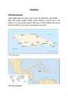
Jamaica rannajoon on 1022km pikk ja 1,5% pindalast on vesi ning ülejäänud maismaa. Riigi suurus on 10991 ruutkilomeetrit ning seal elab 2804332 (2008) inimest keskmiselt tihedusega 245,3 inimest/km². 1. Pilt: Jamaica kaart. 2. Pilt: Jamaica paiknemine. Jamaicas ametlik rahatäht on Jamaica dollar (JMD). Ametlikuks riigikeeleks on Inglise keel. Kingston on Jamaica pealinn kus 2001a. seisuga elab 651880 inimest. Suuremad linnad on veel: Kingston, Portmore, Spanish Town, Mandeville, Ocho Ros, Port Antonio ja Montego Bay. Enamus linnasid paiknevad rannikualal. Jamaica asub troopilises kliimavöötmes ehk kuuma ja niiske õhuga kohas. Atlandi ookeani orkaanidevööse kuulub ka Jamaica. Saar on enamasti mägine, kujult pikklik ja sakilise rannajoonega. Jamaica kõrgeim koht on Blue Mountain Peak (2256 m). Saar Avastatud Christopher Columbuse poolt 1494. Kujunes välja Hispaanlaste poolt 16. sajandil