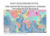
Raukas, A., Teedumäe, A. (eds). 1997. Geology and Mineral Resources of Estonia. Estonian Academy Publishers, Tallinn. 436 pp. Fig. 160. Zonation of the bedrock topography (after Tavast 1992): 1 - boundaries of large bedrock forms; 2 - boundaries of medium bedrock forms; 3 - escarpments. I - Depression of the Gulf of Finland: 1 - Sub-Vendian Peneplain; 2 - Cambrian-Vendian Peneplain; 3 - Vendian Escarpment; 4 - Cambrian Escarpment. II - Viru-Harju Plateau: 1 - Ordovician Escarpment; 2 - Pandivere Elevation; 3 - Ahtme Eminence. III - Livonian Lowland: 1 - West-Estonian Lowland; 2 - Depression of the Gulf of Riga. IV - Middle-Devonian Plateau: 1 - South- Sakala Elevation; 2 - Otepää Elevation; 3 - North-Vidzeme Depression. V - Central-Estonian Lowland and Depression of Lake Võrtsjärv. VI - Lake Peipsi Depression. VII - Valga and South-Estonian lowlands. VIII - Upper-
Heavvy storms and extensive floods are rare. LANDSCAPE Estonia is mostly flat with average elevation of only about 50 meters above sea level. The relief of the present day lanscape was shaped suring the Ice Age. The hilly terrain was also shaped by the continental ice and melting waters. The land still rises 25 cm in every 100 years. Kalevipoeg, the national hero, is related to many features of the relief. The Baltic Glint is one of the world's most important denudations of Ordovician sedimetary rocks. Half of Estonia is covered with forests and 30 % is covered with wetlands. The areas which are higher and particularly rich in hills are the Haanja and Otepää Uplands in the southeastern part of Estonia. In Haanja Upland there is the highest top of Estonia, Big Egg Hill (318 m), which is the highest top of the Baltic states. There are over 1400 lakes in Estonia. Lake Peipsi, lying between Estonia and Russia, covers 3 555 sq km
rising 25 cm every one hundred years. In folklore, many features of the relief are explained by the activities of giants such as the legendary national hero Kalevipoeg. The Haanja and Otepää Uplands are particularly rich in Hills. It is here that You find Big Egg Hill, the highest point in the Baltic states with 318 metres above sea level. 4. Land regions The northern coast features a steep limestone bank, the Baltic glint, which is one of the world's most important denudations of Ordovician sedimentary rocks. The glint rises to its highest point (56m) at Ontika. Estonia has over 1,500 islands. The largest of them are Saaremaa, Hiiumaa, Muhu and Vormsi. There are over 1,400 lakes in Estonia, biggest being Lake Peipsi and Lake Võrtsjärv, while the deepest is Rõuge Suurjärv. The two longest rivers are the Võhandu and the Pärnu and the widest is Emajõgi. About 50% of the country is covered by forests while wetlands cover 30%