Maavärinad
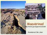
during the October 4, 1994, earthquake.
The initial depth of the crack was 30
meters. However, it quickly filled up with
gravel and larger pieces of rock as a result
of shaking from aftershocks. Photo credit:
V.K. Gusiakov
The same location as in photo 1. The
major scarp of about 300 m in length
formed as a result of ground shaking
and a landslide during the October 4,
1994, earthquake. The major vector of
landslide movement was directed to
the left. View is to the south. Photo
credit: V.K. Gusiakov
�Earthquake of June 16, 1964, Niigata, Japan.
The magnitude 7.4 earthquake killed 26 and destroyed 3,018 houses and
moderately or severely damaged 9,750 in Niigata prefecture.
http://www.ngdc.noaa