North Carolina Annika Rösler Origin of the state l Nickname: Tar Heel State l Origin of name: In honor of Charles I of England l State abbreviation: N.C./NC l Name for Residents - North Carolinians Basic l Capital: Raleigh l Motto: Esse quam videri (To be rather than to seem) l Largest City - Charlotte Size l Land area: 48,711 sq mi. (126,161 sq km) l 2010 resident population est.: 9,535,483 l Number of counties: 100 l North Carolina is the 28th biggest state in the U.S Joining the Union l Entered Union (rank): Nov. 21, 1789 l North Carolina was the 12th state to join. l North Carolina joined the Confederacy during the Civil War. State flag North Carolina's official flag was adopted in 1885. l Symbols l Flower: dogwood (1941) l Tree: pine (1963) l Bird: cardinal (1943) l Mammal: gray squirrel (1969) l Insect: honeybee (1973) l Reptile: eastern box turtle (1979) Symbols l Gemstone: emerald (1973) l
Region Important cities Industry Farming South Bristol, Weymouth, Cheddar cheese, sheep West Poole, Plymouth, cider, tin, stone, Exeter , Salisbury, Bath, clay, engineering, Gloucester ship building, electronics, food processing, computers, cars. South East Oxford,Reading,Windsor The largest oil Fruit refinery,hovercroft farms,Lamberhurst, factories,nuclear Apples,hops,brewing power station, beer East of Cambridge , Norwich , Fishing , cereals, sugarbeet, England Ipswich, fru...
North York Moors Koostaja: Siim Isup Juhendaja: Tiina Tuuling North york National Park...........3 What makes this a special place...4 The hills...........................................5 Natural History..................................6 Entertainment.....................................7 The North York National Park 1436 km2 25000 National park-1952 What makes this a special place Click to edit Master text styles Second level Third level Fourth level Fifth level The hills
NATO – North Atlantic Treaty Organisation e. Põhja Atlandi Lepingu Organisatsioon - Lääne riikide üheks tähtsamakas sõjaliseks ning poliitiliseks liiduks, mis sai asustatud 4.aprill 1949.a. 1955 moodustas NSV koos Ida- Euroopa liitlastega Varssavi Lepingu Organisatsiooni, mis tegutses 1991. aastani. Loomise aluseks sai Põhja – Atlandi pakt, alustajaliikmeid oli 12: USA, Kanada, Suurbritannia, Portugal, Itaalia, Belgia, Holland, Luksemburg, Norra, Taani, Island, Prantsusmaa, kus viimane lahkus 1960.aastal, aga tegutses edasi poliitilises organisatsioonis. NATO-ga liitusid mingi aeg veel Kreeka, Türgi ning Saksamaa Liitvabariik. 1999. Aastal liitusid organisatsiooniga sotsialismimaad – Tšehhi Vabariik, Ungari, Poola. Hiljem, aastal 2004. Liitusid veel Läti ja Leed, sealhulgas Eesti ning veel mitmed riigid. Nagu öeldakse: ,,üks kõigi vastu, kõik ühe vastu’’ – nii kehtib ka NATO leping. Kui rünnatakse ühte neist riiki, võetakse seda ...
NORTHERN LIGHTS LIINA VIROLAINEN 12A CLASS KEILA KOOL NORTHERN LIGHTS Northern lights is a common name for the Aurora Borealis in the Northern Hemisphere. Where can we see the northern lights? The Northern Lights, as the name suggests, are especially related to the polar regions. They occur most frequently in a belt of radius 2500 km centered on the magnetic north pole. This so-called auroral zone extends over northern Scandinavia, Island, the southern tip of Greenland and continuing over northern Canada, Alaska and along the northern coast of Siberia. How often can you see the Northern Lights? In Troms and Finnmark, we can see the Northern Lights every other clear night, if not even more frequently. From southern Norway, only a few times a month while in central Europe hardly more than a few times a year and they have even been seen from
The Chiltern Hills Ursula 11. kl · The Chiltern Hills are known locally as just The Chilterns and are a chalk escarpment in the south-east of England, lying a few miles north-west of London. · They cover four counties and combine beautiful scenery with interesting history. · The Chilterns begin in Oxfordshire in the Thames Valley and stretch north-east through Buckinghamshire and Bedfordshire to Hitchin in Hertfordshire. They comprise of chalk hills covered with beautiful beech woods, wild flowers, and a variety of wildlife. History · In pre-Roman times, the Chiltern ridge provided a relatively safe and easily negotiable route across southern Iron Age England, thus the Icknield Way (one of England's ancient trackways) follows the line of the hills. · The name "Chiltern" comes from the Cilternsæte, a tribe that occupied the area in the early...
Geordie (Newcastle upon Tyne) Lancastrian (Lancashire) Scouse (Merseyside) Mancunian-Salfordian (Manchester & Salford) Mackem (Sunderland) Northumbrian (rural Northumberland) Pitmatic (Durham and Northumberland) Yorkshire (also known as Tyke) In the far north, local speech is noticeably Scots in nature. o East Midlands o West Midlands Black Country English Brummie (Birmingham) Potteries (north Staffordshire) o Southern Received Pronunciation Cockney (East London) East Anglian (Norfolk, Suffolk and North Essex) Estuary (Thames Estuary)
Table of Contents 1.Alaska info...................................3.lk 2.Geography.....................................4.lk 3.Natural features......................5.lk 4.Climate...........................................6.lk 5.Pictures.........................................7.lk 6.Used Sources..............................8.lk Alaska info Alaska is the largest state in the United States by area. It is situated in the northwest extremity of the North American continent, with Canada to the east, the Arctic Ocean to the north, and the Pacific Ocean to the west and south, with Russia further west across the Bering Strait. Alaska is the least densely populated state of the U.S. 2 Alaska was purchased from Russia on March 30, 1867, for $7.2 million at approximately two cents per acre. The land went through several administrative changes before becoming an organized territory on May 11, 1912, and the 49th state of the U.S. on January 3, 1959
NEW ZEALAND Geography: New Zealand is situated midway between the Equator and the South pole in the southern Pacific Ocean. It consists of two large islands, North Island and South Island, plus several smaller ones of which Stewart Island is the largest. North and South Islands are separated by the 32km wide Cook Strait. The total land area is 270,535 sq Km, about the size of Italy, the United Kingdom or the US state of Colorado. North Island is volcanically active with three active volcanoes. South Island has the high snow covered mountain peaks and glaciers of the Southern Alps, a range running almost 500Km along the Island. The longest river is the Waikato on North Island (425 Km), the largest inland stretch of water is Lake
Broadway Broadway is a road in the USA of New York. Perhaps best known for the portion that runs through the borough of Manhattan in New York City, it actually runs 21 km through Manhattan and 3.2 km through the Bronx, exiting north from the city to run an additional 29 km through the municipalities of Yonkers, Hasting- On-Hudson, Dobbs Ferry, Irvington and Tarrytown and terminating north of Sleepy Hollow in Westchester County. It is the oldest north–south main thoroughfare in New York City, dating to the first New Amsterdam settlement. The name Broadway is the English literal translation of the Dutch name, Breede weg. Broadway is known widely as the heart of the American theatre industry. Broadway was originally the Wickquasgeck Trail, carved into the brush of Manhattan by its Native American inhabitants. This
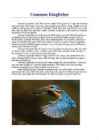
It's wings are short and wide and about 7-8cm long. It has short and straight-cut tail. Beak is long, straight and with suddenly outreaching end. Common Kingfisher's head, back and wing feathers are azurite blue, pate has black and light blue stripes. Common Kingfisher is also known as Eurasian Kingfisher or River Kingfisher. Common Kingfisher lives in Eurasia and North-Africa, except for North-Scandinavia. In Finland it lives at south coast, in Africa it lives in north from Sahara. In Asia it lives in North-Turkey, Caucasia, West-Iran, India, East-China and more. It is resident in much of its range, but migrates from areas where rivers freeze in winter. In winter Common Kingfisher travels from north to Mediterranean countries. It is a rare bird in Estonia, up to 1000 birds in summer, and 100 birds in winter. Common Kingfisher likes to live by rivers with steep riverside banks, where the water is clean and still, and flow is slow
Washington is a state in the Pacific Northwest region of the United States located north of Oregon, west of Idaho and south of the Canadian province of British Columbia, on the coast of the Pacific Ocean. Washington is one of the great states that make up the United States of America. The United States of America accepted Washington as the 42nd state to enter the union.Capital of the United States is Olympia. The population was 46,478 at the 2010 census. Date of the statehood is 11. november in 1889. Washington state population is 6,287,759.
ENGLAND General overview England is part of the United Kingdom Land borders with Scotland to the north and Wales on to the west The English Channel on south separates it form continental Europe The country includes over 100 smaller islands Capital and largest city is London Its has consitutional monarchy Monarch is Elizabeth II Total area is 130,395 km2 Population is 51,446,000 million, around 84% of the population of the UK Currency is Pound stearling(GBP) Has left-hand traffic Patron saint is ST. George Geography
New Zealand New Zealand is an island country. It is in the south-western Pacific Ocean comprising two main island, North- and the South Island with lots of smaller islands. New Zealand is notable for its geographic isolation. It's about 1,600 kilometers from Australia and its closest neighbours to the north are New Caledonia, Fiji and Tonga. New Zealand's total land area is 268,021 square kilometers. The country extends more than 1600 kilometers along its main,north - north-east axis and has about 15,000 kilometers of coastline. The South Island is the largest land mass of New Zealand and is divided along its lenght by the Southern Alps and the highest mountain Mount Cook is 3,754 meters high. There are 18 peaks over 3000 meters in the South Island. The highest North Island mountain
return currentRoom;
}
// Player.h
#ifndef PLAYER_H
#define PLAYER_H
#include "Room.h"
#include
Scotland ! Scotland (Gaelic: Alba) is a country in northwest Europe that occupies the northern third of the island of Great Britain. It is part of the United Kingdom, and shares a land border to the south with England. It is bounded by the North Sea to the east, the Atlantic Ocean to the north and west, and the North Channel and Irish Sea to the southwest. In addition to the mainland, Scotland consists of over 790 islands including the Northern Isles and the Hebrides. Edinburgh, the country's capital and second largest city, is one of Europe's largest financial centres. It was the hub of the Scottish Enlightenment of the 18th century, which saw Scotland become one of the commercial, intellectual and industrial powerhouses of Europe. Scotland's largest city is Glasgow, which was once one of the
Indian foods Indian Food Indian food is different from rest of the world not only in taste but also in cooking methods. Just like Indian culture, food in India has also been influenced by various civilizations Foods of India are better known for its spiciness. Throughout India, be it North India or South India, spices are used generously in food. North Indian Food Food in the north India, to begin with, Kashmiri cuisines reflect strong Central Asian influences. In Kashmir, mostly all the dishes are prepared around the main course of rice. One delicious item cooked here is the 'Saag' that is prepared with a green leafy vegetable known as the 'Hak'. Click to edit Master text styles Second level Third level Fourth level Fifth level West Indian Food
The United States of America The United States of America is situated mostly in central North America, where it lies between the Pacific and Atlantic Oceans, bordered by Canada to the north and Mexico to the south. The state of Alaska, which is located northwest from the continent, and Hawaii Islands, which are located in the mid-Pacific, are also part of the United States. The country also possesses several territories in the Caribbean and Pacific. It consists of 50 states. United States is the third largest country with the territory of 9.83 million km2. It's population is about 309 million. USA became an independent country on July 4, 1776
300km of the US border. Most First Nations live in reservations in the southern part of the country. If you look at the map of the world, you will notice what a huge country Canada is. It is the second largest country in the world, xceeded only by Russia. From St. John`s to Victoria Canada stretches about 7000km. In fact, Canada`s east coast is closer to Europe than it is to Canada`s west coast. It also extends southward from the North Pole to the US border. Canada`s northen coast is washed by Arctic Ocean, eastern coast by the Atlantic Ocean and western coast by the Pacific Ocean. Canada is so big that it contains six time zones. This huge land mass has been divided by nature into 6 distinct geographical regions. Stretching across the north is the Artic region. On the east there is another geographical unit called the Applachian Region after the range of mountains which run through the New England states north into Canada
Montreal and Vancouver ▶ Population: 36 milj Symbols ▶ Flag:A vertical triband of red and white with the red maple leaf centred on the white band. ▶ Goat of Arm: ▶ Plant: Maple tree ▶ Animal: Beaver and Canadian horse Geography ▶ Canada is the second-largest country in the world, after Russia ▶ Between the North Pacific Ocean to the west and the North Atlantic Ocean to the east and the Arctic Ocean to the north Interesting facts ▶ Canada is home to the longest street in the world ▶ Canada has twice been invaded by the USA, first in 1775 and again in 1812 ▶ Canada has more lakes than the rest of the world’s lakes combined ▶ Licence plates in the Canadian Norhtwest Territories are shaped like polar bears
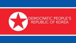
DEMOCRATIC PEOPLE’S REPUBLIC OF KOREA Overview ◦Capital: Pyongyang ◦Population: 25.37 million ◦Supreme leader: Kim Jong-un ◦Eternal leaders: Kim Il-sung, Kim Jong- il Kim Il-sung's rule ◦Korea split in half ◦Free elections Kim Il-sung's rule ◦The Korean War (1950-1953) ◦Juche Kim Jong-il's rule ◦Songun ◦Arduous March ◦Kim Jong-un List of used sources ◦ http://www.zerohedge.com/sites/default/files/images/user5/imageroot/north%20ko rea%20night%20photo_0.jpg ◦ http://www.dummies.com/education/history/world-history/a-brief-history-of-north-kor ea/ ◦ https://en.wikipedia.org/wiki/Kim_Il-sung#/media/File:Kim_Il_Sung_Portrait-2.jpg ◦ https://en.wikipedia.org/wiki/Korean_Demilitarized_Zone#/media/File:070401_Panm unjeom3.jpg ◦ https://qph.ec.quoracdn.net/main-qimg-0af26693c835b5b031db281e3dbbb96f-c ◦ http://apjjf.org/data/43032.jpg ◦ http://www.travelpostersonline.com/ekmps/shops/travelposters/images/north-korean-p ...
According to Canadian census 2011, 1.4 mln people of Aboriginal origin (4.3%): 852,000 First Nations persons, 452,000 Métis, 59,000 Inuit. Indian (First Nations) - No written history before the contact with Europeans. Chief historical sources European priests, travellers and traders not interested in the preservation of "pagan"myths. Different estimates about their number in Canada when Europeans reached North America from 300,000 to 1 mln. Saw themselves as part of nature, not as its masters. The First Nations were called "Indians" by Christopher Columbus when he landed in North America, because he thought he had reached India. Many now prefer to call themselves First Nations, though many still call themselves Indians in everyday conversation. They are still legally categorized by the Canadian Government under the Indian Act as Status Indians. Those who
parts of Asia about 15,000 years ago. They crossed the Bering Strait from Siberia to Alaska. Some of those people followed the Yukon River and found their way south. Others followed the MacKenzie River which opened the way to the plains of the interior, and then travelled on to the Great Lakes and the St. Lawrence River. The third group of people inhabited the Arctic regions. The first two groups were called Indians, the group that settled in the north were called Eskimos. These people are the only true native Canadians, the rest are new Canadians who have been transplanted from other parts of the world, especially from Europe. The first European visitors to North America were Norsemen who settled briefly in the 11th century. John Cabot, a Venetian seeking riches for England, made the next known voyage in 1497. He took back word that the sea was full of fish which could be taken not only with a net but in baskets let down into the water.
England is a country that is part of the United Kingdom.It shares land borders with Scotland to the north and Wales to the west; the Irish sea is to the north west, theCeltic sea to the south west and the North Sea to the east, with the English Channel to the south separating it from continental Europe. The mainland of England consists of the central and southern part of the island of Great Britain in the North Atlantic but England also includes over 100 small isl such as the Isles of Scilly and the Isles of weight.The area now called England has been settled by people of various cultures for about 35,000 years, but it takes its name from the Angles, one of the Germanic tribes who settled during the 5th and 6th centuries. England became a unified state in AD 927, and since the Age of Discovery, which began during the 15th century, has had a significant cultural and legal impact on the wider world.
Tallinn English College CANADA Report Karin Kristen Tapupere 8.b Instructor: Tiiu Martma Intro: Canada is a country occupying most of northern North America, extending from the Atlantic Ocean in the east to the Pacific Ocean in the west and northward into the Arctic Ocean. It is the world's second largest country by total area and its common border with the United States to the south and northwest is the longest in the world. The land occupied by Canada was inhabited for millennia by various groups of Aboriginal people. Beginning in the late 15th century, British and French expeditions explored, and later settled along, the Atlantic coast
field hockey played in England. Where necessary, these seem to have been adapted for icy conditions; for example, a colonial Williamsburg newspaper records hockey being played in a snow storm in Virginia. Early paintings show "shinney", an early form of hockey with no standard rules, being played in Nova Scotia in Canada. NHL The National Hockey League (NHL) is a professional ice hockey league composed of 30 teams in North America. It is considered to be the premier professional ice hockey league in the world and one of the North American major professional sports leagues. The Stanley Cup, the oldest professional sports trophy in North America is awarded annually to the league champion at the end of each season.
Estonia is a state in the Baltic region of Northern Europe. It is bordered to the north by the Gulf of Finland, to the west by the Baltic Sea, to the south by Latvia (343 km), and to the east by Lake Peipus and Russia (338.6 km). Across the Baltic Sea lies Sweden in the west and Finland in the north. The territory of Estonia covers 45,227 km2 (17,462 sq mi), and is influenced by a humid continental climate. The Estonians are a Finnic people, and the official language, Estonian, is a Finno-Ugric language closely related to Finnish, and distantly to Hungarian and to the Sami
cultural diversity of different nations in Canada. All the communities living in the country are encouraged to remember their origins and hold their own ethnic events and national festivals. Cultural diversity makes Canada even more interesting. In spite of this, in recent years there is a strong movement in French-speaking Quebec to become an independent country. There are many different native people throughout Canada like the Crees, Mohawks, Troquois and Sioux. In the north of the country, the Inuit (Eskimos) now have a self-governing homeland called Nunavut, meaning our land. It is over two million square kilometers and it is inhabited by 17,500 Inuits. The national symbol of Canada is the maple leaf. The national tree is the maple. Canada is also the most tolerant societies in the world because only 13% of Canadians say that they would object their children marrying somebody of a different race, compared with 32% in the USA.
Wales, Germany, Ukraine and Scandinavia. In Edmonton and Calgary there are also historic Chinatowns, and Calgary has Canada's third largest Chinese community. Geographical features Alberta covers an area of 661,848 square kilometres, an area about 5% smaller than Texas or 20% larger than France. This makes it the fourth largest province after Quebec, Ontario, and British Columbia. To the south, the province borders on the 49th parallel north, separating it from the U.S. state of Montana, while on the north the 60th parallel north divides it from the Northwest Territories. To the east the 110th meridian west separates it from the province of Saskatchewan, while on the west its boundary with British Columbia follows the 120th meridian west south from the Northwest Territories at 60°N until it reaches the Continental Divide at the Rocky Mountains.
The usage of forests: 1. Gathering · To live, get food and shelter from the woods · Don't change or harm the forests 2. EarlyAgrarian m.m. · Slash and burn -> woods replaced by brush (võsa) · Typical to Mediterranean region and East-Asia 4. Late Agrarian m.m · Very bad situation primeval fields · Population growing necessity much bigger · Forests preserved on slopes of mountains and where infertile soils were. · West Europe, North America 4. Early Industrial m.m · Development of forestry -> timber industry · Wood from boarderlands and colonies · Subequatorial and equatorial regions valuable woods · Temperate zone coniferous woods soft timber · Transport floating of logs, road transport 5. Late Industrial m.m · Ruinous economy Forestry in different regions of the world: 1. Europe 1) West Europe · A lot of forests were destructed during Late Agrarian times.
tasakaalustatud maailmamajanduse arengut. · Rahvusvahelise valuutafondi finantsabi kasutatakse aitamaks riiki ajutiste maksebilansiprobleemide ilmnemisel, et vältida likviidsuskriisi ning selle võimalikku negatiivset mõju majanduskasvule ja teistele riikidele. · Riigivõimude oskusteabe tugevdamiseks majanduspoliitika planeerimise ja rakendamise osas pakub tehnilist abi. NATO- PÕHJA-ATLANDI LEPINGU ORGANISATSIOON (Inglise k. North Atlantic Treaty Organization) NATO on iseseisvate riikide poliitilise ja sõjalise koostöö liit. NATO tagab liikmesriikide julgeoleku ja lisaks suveräänsele kaitsevõimele ka teiste liikmesriikide sõjaliste jüudude abil. NATO loodi 1949. aasta aprillis, Ühinenud Rahvaste Organisatsiooni põhikirja artikli 51 raames sõlmitud Põhja-Atlandi lepinguga. Lepingu allkirjastanud 12 Põhja-Ameerika ja
Still highly centralized though committed to these struggles, including legal states are not controlled by same parties as federal government challenges and violence necessarily. Evidence that centralised image of South African Budget imbalance budgetary authority being devolved, though still territorial politics over-simplified? centralized. State governments in north eg hampered by low taxes (to No the provinces remain fairly lacking in attract business) and inability to raise revenue through bonds. Thus, power, but there is a lot of politics going on there infrastructure development dependent on federal government. eg issues around corruption, political Legacy of post-revolution consolidation of state power in federal appointments, intra-party politics etc. executive.
The United States of America General information Location: North-America, bordering both the North- Atlantic Ocean and the North-Pacific Ocean, between Canada and Mexico Area: 9.5 million square km Population: 302 million (most from European immigrants; 30 million African Americas; 2 million American Indians) Language: English 81,1 %, Spanish 10,7 %, other Indo- Euroean 3,8 %, Asian and Pacific island 2,7%, other 0,7% (the official language in Hawaii is Hawaiin) Head of State: the President (Barack Obama) Head of Government: the President Independence Day: 4th July 1776 Capital: Washington Largest City: New York (7.3 m) National Emblem: the bald-headed eagle National Currency: US dollar Government The U.S. Federal Government was formed in the eighteenth century, and the United States is considered to be the first modern national federation in the world. Th...
Berry Islands East Grand Bahama Bimini Exuma Black Point, Exuma Grand Cay, Abaco Cat Island Harbour Island, Eleuthera Central Abaco Hope Town, Abaco Central Andros Inagua Central Eleuthera Long Island City of Freeport, Grand Mangrove Cay, Andros Bahama Mayaguana South Andros Moore's Island, Abaco South Eleuthera North Abaco Spanish Wells, North Andros Eleuthera North Eleuthera West Grand Bahama Ragged Island Green Turtle Cay Rum Cay San Salvador South Abaco National symbols Ethnic Groups AfroBahamians85% Europeans12% Hispanic3% Asian/IndoCaribbean3% Culture/traditions Voodoo dolls Obeah Junkanoo Emancipation Day Voodoo Dolls Voodoo is a powerful mystical practice that can
The Inuits came to Canada from Asia crossing the Bering land bridge. The earliest discoveries in Canada were made by the Vikings. In AD 985 Vikings sailing from Iceland to Greenland were blown westward off their course and the Vikings sighted the coast of Labrador peninsula. The report of forested areas encouraged further exploration because the colonies in Greenland which belonged to the Vikings lacked lumber. In AD 1000 Leif Ericson became the first European to land in North America. The first colony was established what was described as Vinland by the Vikings. It was located on the northernmost tip of todays Newfoundland. There has also been a theory that the Vikings penetrated Hudson Bay and reached the Great Lakes region but recent investigations have cast serious doubt on it. The Greenland colony died out during the 15th century and the Viking adventures in Canada must have come to an end long before that time. The Colony of New France
85% of the whites are British or Irish, a lot of immigrants are from Yugoslavia lands, like Croatia (800 000), Greek (600 000), Italy (600 000) and Polish (200 000) . Government: Federal parliamentary democracy and constitutional monarchy, monarch is Queen Elizabeth II, Governor General is Quentin Bryce and Prime Minister is Kevin Rudd. Climate: Most part of Australia is located in tropics zone. Equatorial climate rules in Queenslands north, and tropical monsoonclimate rules West-Australia and north territory, and queenlands north-western. Subtropical climate remains South- Australia south and New-South-Wales. Temperate zone rules in South-Victoria and in Tasmanite. Midland, west- and south are very dry. Moderate climate is only in east and south-east 400 km coastline and in south-west. Sightseen: Sydney Tower tallest independent tower in sydney Opera in Sydney a symbol for not only a city, but a whole country and
written in 1814 by Francis Scott Key. There are 6 time zones. From east to west they are: Eastern Standard Time, which is 5 hours behind Greenwich Time, Central Standard Time, Mountain Standard Time, which is 7 hours behind Greenwich Time, Pacific Standard Time. Alaska and Hawaii have their own time zones: Alaska Standard Time and Hawaii Standard Time. Geographical Position The USA lies in the Northern Hemisphere in North America. It covers a big part of the continent and is also the third largest country in the world. The country consists of 50 states, but two of them lie separately. One of them is Alaska, which is near the Arctic Circle. And the other state is Hawaii, which is a group of island is the Pacific Ocean. The USA shares the border with Canada in the north and Mexico in the south. In the east the coast is washed by the Atlantic Ocean and in the west by the Pacific Ocean
More exactly about 68 920 km² is made up by lakes and rivers. Climate in australia is dampish and warm. Australia's capital is Canberra, but the largest city is Sidney. The symbol of Australia is kangaroo, it's the biggest marsupial (kukkruloom) in the world. Also it has the greatest number of reptiles (roomajad) of any country, more than 700 species. United Kingdom consists of England, Scotland, Wales and Northern Ireland. It is girded (ümbritsema) from North Sea, strait of La Manche and Atlantic Ocean. Total area of United Kingdom is 244 820 km² and population is 60 776 000 people. England is part of the united kingdom. England's territory occupies most of the island of Great Britain. It has northern land border (piir) with Scotland and west land border (piir) with Wales. The capital on England is London and its also the biggest city. Official language is English. It's total area is 130 395 km². In england defenatly worth looking is
the lower hoist-side quadrant known as the Commonwealth or Federation Star, representing the federation of the colonies of Australia in 1901; the star depicts one point for each of the six original states and one representing all of Australia's internal and external territories; on the fly half is a representation of the Southern Cross constellation in white with one small five-pointed star and four larger, seven-pointed stars Borders Australia · North East of Australia is the Coral Sea · South West of Australia is the Indian Ocean ·North of Australia is the Gulf of Carpentaria ·North West of Australia is the Timor Sea ·south great Australian bight Australia Click to edit Master text styles Second level Third level Fourth level Fifth level Click to edit Master text styles Second level
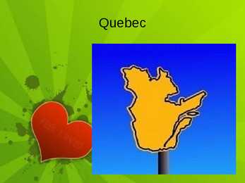
Quebec Quebec Province in east-central Canada. The only Canadian province with a predominantly French- speaking population. Largest province by area. second-largest administrative division. Bordes West by the province of Ontario, James Bay and Hudson Bay. North by Hudson Strait and Ungava Bay. East by the Gulf of Saint Lawrence, Newfoundland and Labrador and New Brunswick. South the U.S.A. Geography 90% of Quebec's territory lies within the Canadian Shield The Eastern Canadian forests cover the Appalachian Mountains Climate Most of central Quebec has a subarctic climate. Winters are long, very cold, and snowy. Summers are warm but very short
Canada. Canada is a very big country in the continent of North America. It is about 10 million square kilometres and that makes it the second largest country in the world after Russia. Quebec (the province) is six times as big as the UK. Canada borders the Atlantic Ocean, the Pacific Ocean, the Arctic Ocean and the USA. The capital of Canada is Ottawa and other main cities are Toronto, Montreal and Vancouver. It is a very developed country. Montreal is the largest city and it is called the Paris of North America because most of the people there speak French
SCOTLAND Made by · is in northwest Europe that occupies the northwest Europe northern third of the island of Great Britain · part of the United Kingdom · bounded by the North Sea to the east, the Atlantic Ocean to the north and west, and the North Channel and Irish Sea to the southwest Flag Coat of arms Data · Capital: Edinburgh · Largest city: Glasgow · Languages: English, Gaelic, Scots · Demonym: Scottish · Head of State: Queen Elizabeth II · Total area: 78,772 km² (water 1.9%) · Population: 5,144,200 people · Currency: Pound sterling · Patron Saint: St. Andrew National symbols: thistle kilt tartan pattern bagpipe Flower of Scotland (national anthem)
2 Official Languages English and French Government system constitutional monarchy and federal parliamentary diplomacy POLITICAL SYSTEM Constitutional monarchy Elizabeth II, Queen of Canada, head of state Governor General appointed by the monarch Parliamentary democracy Similar parliamentary system to other Commonwealth realms Federation "One Dominion under the name of Canada" with the Constitution Act of 1867 GEOGRAPHY Located in North America, north of USA Territory - 9,984,670 km2 World's second largest country CLIMATE Due to large territory, climate varies in greatly ECONOMY One of world's wealthiest nations 1,406,000 GDP 9th in the world About ¾ of Canadians employed in service industry Unusually high importance of primary sector Logging and oil industry two of Canada's most important One of world's most important agricultural suppliers World leader in many natural resources
Wales English (a.80%) Welsh (a.20%) Offical languages Capital and largest city: Cardiff Goverment: Constitutional monarchy Total area: 20,779 square kilometers Population: 3,006,400 (estimate June 2010) Currency: Pound sterling (GBP) Facts about Wales Pictures about Wales Wales is a generally mountainous country on the western side of central southern Great Britain, between the Irish Sea to the north and the Bristol Channel to the south. It is part of the United Kingdom, and is bordered by England to its east and the Atlantic Ocean, St George's Channel and Irish Sea to its west. It is about 274 km from north to south and at least 97 km wide, with a total area of 20,779 km2. It has over 1,200 km of coastline, and includes offshore islands of which the largest is Anglesey. Wales geography and environment The Economy of Wales. In 2010, according to ONS provisional data,
Spanish California Sten Endrik Mihkelsoo MM-14 California's contact with Europeans began in the mid 1530s when Cortez's men ventured to Baja California. Not until 1542 did Spaniards sail north to Alta California, and Juan Rodriguez Cabrillo's expedition of that year made landings as far north as modern Santa Barbara. The Spaniards, of course, were hardly the first to discover this land of wonder and extremes. The earliest Californians were adventurous Asians who made their way across the Bering Straits to Alaska thousands of years ago when a warmer climate and a now-vanished land bridge made such travel easier. These men and women and their descendants settled North and South America, spreading out to form the various nations and tribes
Street, to the north; Charing Cross Road, to the east; Orange Street, to the south; and Whitcomb Street, to the west. The park at the centre of the Square is bound by Cranbourn Street, to the north; Leicester Street, to the east; Irving Street, to the south; and a section of road designated simply as Leicester Square, to the west. It is within the City of Westminster, and about equal distances (about 400 yards / 370 metres) north of Trafalgar Square, east of Piccadilly Circus, west of Covent Garden, and south of Cambridge Circus. Piccadilly Circus Piccadilly Circus is a road junction and public space of London's West End in the City of Westminster, built in 1819 to connect Regent Street with the major shopping street of Piccadilly. In this context, a circus, from the Latin word meaning "circle", is a round open space at a street junction.
Geography Canada is the world's second largest country in total area after Russia , since it covers nearly 10 million square kilometres, but is one of the most sparsely populated, with only about 34 million inhabitants. The majority of them live within 300 kilometres of Canada's southern border. Much of the rest of Canada is uninhabited or thinly populated, because the country has a rugged terrain and severe climate. Canada extends across the continent of North America, from Newfoundland on the Atlantic coast to British Columbia on the Pacific coast and northward into the Arctic Ocean. Canada shares land borders with the United States to the south and north-west. Canada is a land of great variety. Towering mountains, crystal-clear lakes, and lush, green forests make Canada's far west a beautiful region. Farther inland, fields of wheat and other grains cover Canada's vast prairies
Elu tänapäevases Põhja-Koreas Aysel Alieva Sissejuhatus · Töö eesmärk on tutvustada igapäevast elu Põhja- Koreas ja inimeste õigusi. · Töö esimene osa tutvustab Põhja-Korea riigi teket ja teine tutvustab elu. · See töö on väga aktuaalne, sest osad inimesed on huvitatud Koreast. · Töö on suunatud kõikidele, kes on teiste riikide kultuuridest huvitatud. Teema valiku põhjendus · Meeldib Korea kultuur, erineb väga Eesti Vabariigist, sellest riigist ei uurita eriti palju. Põhja-Korea riigi teke 20. sajandil · 1910-1945 Jaapani valitsuse all. · Vastu hakkasid Kim Il-sungi juhtimisel. · Moodustati Korea Rahvademokraatlik Vabariik, mille juhiks sai Kim Il-sung. · 1950-1953 konflikt Lõuna- ja Põhja-Korea vahel. Totalitaarne reziim Põhja-Koreas · Totalitaarne reziim. · Pommitamise abil tahab diktaator oma reziimi kindlustada. · On olemas arvutid, televiisorid, internet, autod, kuid ei tähenda, et seda kõike võ...
Tallinn English College Report of Canada 8a Teacher: Merike Sisask Composer: Kärt Kalvet 2010 Canada, Kärt Kalvet 8a Canada General Information Canada is in North America. It's area is 9220970 sq km. Canada's population is 313.612.000 people. Canada is divided into 10 provinces and 3 territories. The capital of Canada is Ottawa. Canada has constitutional monarchy. The head of state in Canada's government is the Queen of England. There are two main languages in Canada: English and French. Canada's curreny is Canadian dollar (1 dollar=100 cents[Can$]). The highest peak of Canada is Mount Logan, 5959 metres. The lowest point is sea level
THE NO ARTICLE · Names in the plural = countries: the Nether- * Names of countries / towns (also with an es- lands, the USA; the West Indies ablished modifier): (South) Estonia, Tartu · Names of the countries, and towns with a * Expressions from North to South etc. characteristing / spacifying modifer: the Tartu of th 19th century * Names of streets, bridges, airports, parks, squares, buildings, railway stations, shops, · Names of rivers, channels / canals, seas, addresses: Fleet Street, Tower Bridge, oceans, streams, straits: the Danube; the Suez Kennedy Airport, Hyde Park, Trafalgar