Juhendaja K.Kalamees
Tõrva 2012
Materjal lk :134
Sissejuhatus
Islandi geisrid on geisrite kodu. Islandil toimuvad kõige tihedamini geisri
pursked ja nad on ka kõige tugevamad. Islandil on kaks kõige klassikalisemat
geisrit Suur Geiser ja Strokkur.
Islandi geisrid
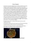
Klassikaline geisrite maa on Island, sest Suure Geisri näol kuulub talle maailma
kuulsaim purseallikas, pealegi ka sõna <
Essay There is not a single country in the world without a history it can be either long or short, yet still a unique part of the existence. England has had many colourful events throughout the history, but some have dominated over the others and therefore all together formed a country we can see nowadays: the Great Britain. Starting from the beginning, Britain was part of the mainland until about 6000 BC, when it became an island. Ever since then it has been developing slightly different from the other part of the Europe. For example, when two parts separated, some animals had already adopted the life on the island and did not move back to the mainland. They suited their appearance more comfortable for the isolated island and learned how to survive in the wet climate and rather heavy air. The first inhabitants the Iberians also had to change in order to survive. They had to renew their menu
Norra ja Islandi kalatööstuse ülevaade (ressursid, areng ja koht maailma majanduses) Islandi rahvas peab end eelkõige kalarahvaks. 1900. aastatel tuli 90% riigi sissetulekutest kalastööstusest. Kuni 20. sajandini oli Island sõltuv kalandusest ja oli üks vaesemaid ja vähim arenenud riike Euroopas. Aga Teise maailmasõja lõpus tõid riigile õitsengu kalapüügi industrialiseerimine ja NATO sõjabaasi paigutamine Islandile. Juba 1990. aastate lõpuks oli Island üks Euroopa rikkamaid riike. Islandi vetes on üle 320 liigi kalu. Levinumad neist on tursk, heeringas, tuunikala ja lõhe. Island ekspordib mereande umbes 1,2 miljardi euro eest ja suurem osa läheb Euroopasse.
1. Mõrdr ja ta tütar Unnr, parim kosjakaup. Höskuldr ja Hrutr ning nende 11. Thorvaldr sõitis oma naise ja Thjostolfiga peolt koju. Naine käis rahaga esivanemad/järglased. Hallgerdri pärast peavad mehed kannatama. pillavalt ümber ja solvas meest ning see lõi siis teda. Hiljem sõitis ta oma Vendade suhted halvad. 8 mehega Karusaartele, et sealt jahu ja vinnutatud kala juurde tuua. 2. Höskuldr ja Hrutr sõitsid Altingile. Hrutri ja Unnri kihlus. Läksid koju. Hallgerdr oli väga löödud. Kasvataja tahab kätte maksta ning tapab mehe. Hrutri onu Özurr ütles, ettema vend Eyvindr oli surnud ja jättis talle Gula 12. Sulased ilmusid kohale, kasvataja uputab paadi ja mehe. Kodu sõites oli tingil päranduse, kuid vaenlased võtavad selle ära, kui ta kohale ei ilmu. Hallgerdr tal vastas ja sai teada, et ta mees oli surnud. Naine annab ...
PÕHJAMAAD · Põhjamaade nõukogusse kuulusid: Rootsi, Taani, Norra, Island ja Soome. · Neid riike eristas teistest eelkõige sotsiaaldemokraatlike erakondade suur mõjuvõim. · Iga maa areng oli ainulaadne. ROOTSI: · Jäi Esimeses maailmasõjas erapooletuks, kuid sõda mõjus ka sellele riigile. Toimus elatustaseme langus. Esile tõusid sotsiaaldemokraatlikud parteid. · Rootsi sotsiaaldemokraadid tegid sõdade vahelisel ajal mitmeid ühiskondlike ümberkorraldusi: töökindlustused, peretoetused, puhkusetasud, 8-tunnine tööpäev jms.
LITOSFÄÄR Kivimid: · Settekivimid: tekkinud setete kivistumisel (tsementeerumisel) Lubjakivi, liivaivi, põlevkivi, kivisüsi · Tardkivimid: tekkinud magma või laava tardumisel maacsees või maapinnal Graniit, gabro- süvakivim Basalt-purskekivim · Moondekivimid: sette- või tardkivimite moondumisel kõrgel temperatuuril ja rõhul. Geniss, marmor, kvartsiid Geoloogiline aineringe e. kivimiringe Ainete liikumine litosfääri ja Maa sügavamate kihtide vahel, mis toimub järgmiste protsesside kaudu: Magma tardumine tardkivimiks Murenemine ja settimine veekogudesse Setete tihenemine settekivimiks Settekivimi või tardkivimi sattumine sügavamatesse kihtidesse ja moondumine moondekivimiks. Litosfäär Maa tahke kivimikes, mis koosneb maakoorest ja astenosfääri peale jäävast vahevöö tahkest...
Kui eelmisel aastal majandus-languse tõttu Islandil krooni väärtus langes, sai saareriigist odav ja populaarne turismisihtkoht. Pärast vulkaanipurset langes aga Islandi populaarsus märgatavalt. Sellepärast käivitati valitsuse ja välisministeeriumi eestvedamisel Internetipõhine kampaania, kus kutsuti kohalikke üles kirjutama midagi head oma riigi kohta. (Hein, Inna-Katrin. ,,Island püüab kampaania abil turismi turgutada". [http://www.tarbija24.ee/?id=271330]) Minu arvates võiks aga Island turismi populaarsuse suurendamiseks kasutada ära ka just vulkaane ja liustikke ning hakata korraldama näiteks erinevaid ekstreemreise vulkaanilistesse piirkondadesse. Maavärinaid, vulkaanipurskeid on võimalik meteoroloogiakeskustes ette ennustada, seega ei seataks turistide elusid päriselt ohtu. Lisaks loob selline lähenemine ka võimalused uute turismikeskuste tekkele ning tööd saavad vanade teenusepakkujate kõrval uued ekstreemreiside korraldajad.
de/29972/, lk 17 10 Spruk Rok (2010) Iceland's Economic and Financial Crisis: Causes, Consequences and Implications, European Enterprise Institute, URL (kasutatud jaanuar 2014) http://mpra.ub.uni-muenchen.de/29972/, lk 17-18 15. Oktoobril, 2008 aastal otsustas Islandi keskpank seda üles ajutise valuutaoksjoni, et hõlbustada rahvusvahelist kaubandust. Kuid jõulise valuutata polnud võimalik toetada panke, mis olid suurema osa oma ärist teinud välisturgudel. 19 novembri jõudsid Island ja Rahvusvaheline Valuutafond kokkuleppe, et alustada riigi stabiliseerimisprogrammi. IMF otsustas riiki toetada 827 miljoni dollariga. Islandi kohustusteks oli pangandussüsteemi kindluse taastamine, vahetuskursi stabiliseerimine ja riigi rahanduspositsiooni parandamine. Ühtlasi tehti muudatusi, mis meelitaksid sisse välisinvestoreid.11 Kreeka majanduskriis. Põhjus, käik, tagajärg 11 Jackson James. K. (2010), Iceland's financial crisis..Current Politics & Economics of Europe.Vol
JAMAICA The english speaking country · Jamaica is an island country situated in the Caribbean Sea, consisting of the third-largest island of the Greater Antilles (*The Greater Antilles is a grouping of the larger islands in the Caribbean Sea). · The flag consists of a gold saltire, which divides the flag into four sections: two of them green (top and bottom) and two black (hoist and fly). · black representing the strength and creativity of the people which has allowed them to overcome the odds, gold for the wealth of the country and the golden sunshine, and green for the lush vegetation of the island.
docstxt/134791922674.txt
Islandi saar on suuruselt teine Euroopa saar Atlandi ookeani põhjaosas, kus paikneb peaaegu kogu Islandi Vabariigi territoorium. Saare pindala on 103 000 km2. Asub Atlandi ookeani põhjaosas Gröönimaa, Šotimaaja Norra vahel. Riigi pealinn on Reykjavík. Peaaegu kogu territoorium paikneb Islandi saarel, mis asub Atlandi ookeani keskahelikul ja on vulkaaniliselt aktiivne. Suurt osa Islandist katavad laavaväljad, millest omakorda osa on kaetud liustikega. Island asub põhjapolaarjoone lähedal 63. ja 66. põhjalaiuse vahel kõrvalisel saarel. Peale suure saare kuuluvad riigile veel lähedal asuvad väikesaared. Norra rannikuni on sealt 1000 km ja Šotimaani 800 km. Teisel pool on Kanada asustatud alad umbes 2000 km kaugusel. Island asub otse lühimal õhuteel Lääne-Euroopa ja Põhja-Ameerika idaranniku vahel. Islandi saar tekkis Atlandi ookeani keskaheliku vulkaanipursete tõttu, mis osutusid sellel
The foundation stones The Island Britain has a mild climate due to the Gulf Stream which brings warm waters from the Gulf of Mexico. The northern part of the island in average 5'C cooler and it's mountainous or hilly and that's why the south has been more populated.. Britain became an island only 5000 years BC after the Ice Age ended. Britain's prehistory The first evidence of human life on the island are dated back to 250 000 BC. 50 000 BC in a milder Ice Age period Britain became habitable again. People from that time were the ancestors of the modern British. 10 000 BC ige age ended and Britain became inhabited by small groups of hunters who probably followed herds of deer. 5000BC Britain became an island and deer died out
Vastuvõtutööalused KT 1. Toatüübid- SGL, TWIN, DBL, SUI, JUN SUI, INVA, ADJ, CON,TRIP, DBL DBL (2xlaivoodi) 2. Vooditüübid- crib, baby bed/baby cot, french bed/couch (diivan),bank bed (nari), LV (lisavoodi) 3. Vaated- parital ov-osaline/peaaegu olemata ov, ov- ookeani vaade, ocean front-ookean otse ees,beach front- rand otse ees, city view-linnavaade, mountain view- mägede vaade, water view- vaade veekogule, island view-vaade saarele, pool view- vaade basseinile. Garden view-vaade aeda. 4. Ametid vastuvõtus-tegema sisse-ja väljaregistreerimisi, sobitama inimesi tubadesse, arveldama, tegema pakkumisi, rääkima reisibüroodega, lahendama klientide probleeme, suhtlema klientidega, andma toateenijatele infot. 5. Mõisted- RO-ainult tuba, ei sööke; BB-majutus+hommikusöök;HB- majutus+2toidukorda;AL-kõik hinnas;FB- majutus+3toidukorda;UAL-kõik
ttatcagttagctaactgctatatgggtcgggctgggttgataaactccggcggtgctgc gggcggtgaaactgacctcagcgatgcagtgcgtactgcggttatcaacaaacgcgcagg cggaatggggctgattcttggacgtaaagcgttcaagaaatcgatggctgacggcgtgaa actgattaacgccgtgcaggacgtttatctcgatagcaaaattactatcgcctga 2) CpG Islands CpG Islands results Results for 1053 residue sequence "eco:b2097 fbaB, dhnA; fructose-bisphosphate aldolase class I [EC:4.1.2.13]; K01623 fructose-bisphosphate aldolase, class I (N)" starting "atgacagata" CpG island detected in region 3 to 202 (Obs/Exp = 1.18 and %GC = 50.50) CpG island detected in region 18 to 217 (Obs/Exp = 1.19 and %GC = 50.50) CpG island detected in region 21 to 220 (Obs/Exp = 1.19 and %GC = 50.50) CpG island detected in region 24 to 223 (Obs/Exp = 1.19 and %GC = 50.50) CpG island detected in region 25 to 224 (Obs/Exp = 1.19 and %GC = 50.50) CpG island detected in region 26 to 225 (Obs/Exp = 1.19 and %GC = 50.50) CpG island detected in region 27 to 226 (Obs/Exp = 1.19 and %GC = 50
liikuma (lahknema ja põrkuma) ning sellega kaasneb mandrite triiv. * Aafrikas on vanemad kivimid, kuna Aafrika, kui maa, on kauem olnud, kui Atlandi ookeani keskosa, mis on alles kerkinud ja mille maakoor on veel õhem. * Kahe mandriliselaama kokkupõrkel on tekkinud Andide mäestik. * Mariaani süvik on tekkinud kahe ookeanilise laama põrkumisel. * Jaapani saared on tekkinud ookeanilise ja mandrilise laama põrkumisel. * Island on selle koha peal, kus ookeanilised laamad lahknevad. Jaapani juures aga ookeaniline ja mandriline põrkuvad. * Kuna Andid asuvad ookeanilise ja mandrilise laama äärealal, kus toimuvad nii maavärinad, kui vulkaanipursked, Himaalaja mäestik asub aga 2 ookeanilise laama äärealal, kus vulkaanipurskeid ei toimu, on ainult maavärinad. * Vulkaani omadused on väga tihedalt seotud, teda toitva magma sulami koostise, gaaside sisalduse ja temperatuuriga. Need mõjutavad vulkaani kuju ja
Bora Bora Today the island is almost entirely dependent on tourism. Bora Bora, as you know is a paradise for honeymooners. This island offers blue skies, blue sea, golden sands and green flora. Vaitape is the largest city of island Bora Bora Some of the bigger industries on the island include deep-sea fishing, with exports going mainly to Japan, as well as mother-of-pearl and pearl production. Agricultural practices produce sugar, vanilla, rum, and copra (used to extract coconut oil). Despite all of these activities, tourism is by far the leading economic contributor. The island has several hotels to cater to tourists, including twelve 4 and 5-store places like Club Med, for example. 3
Bahamas Lisbeth Vinter 10b Location of Bahamas The country lies between latitudes20° and 28°N, and longitudes 72°and 80°W. Bimini, Abaco, Inagua, Andros Island, Eleuthera, Cat Island, Long Island,San Salvador Island, Acklins,Crooked Island, Exuma andMayaguana. Nassau capital city of The Bahamas, lies on the island of New Providence. Mount Alvernia(Como Hill) 63 metres (207 ft) on Cat Island. Population: 309,156 Religions: Baptist 35.4%, Anglican 15.1%, Roman Catholic 13.5%, Pentecostal 8.1%, Church of God 4.8%, Methodist 4.2%, other Christian 15.2%, other Protestant 12%, none or unknown 3%, other 2% The 'other' category includes Jews, Muslims, Baha'is, Hindus, Rastafarians, and practitioners of Obeah Languages: English (official), Bahamian dialect Climate subtropical to tropical moderated significantly by the waters of the Gulf Stream
Referaat Hiiumaa Kairo parts 8b klass Kiili 2011 Contents 1. Hiiumaa 2. Name 3. History 4. Transport 5. Kõpu lighthouse Hiiumaa Hiiumaa (Finnish, Hiidenmaa, German Dagö, Swedish Dagö, Danish Dagø) is the second largest island (989 km²) belonging to Estonia. It is located in the Baltic Sea .north of the island of Saaremaa ,a part of the West Estonian archipelago. Its largest town is Kärdla. Name Hiiumaa is the main island of Hiiu County, called Hiiumaa or Hiiu maakond in Estonian. The Swedish and German name of the island is Dagö (day island),Dagø in Danish -- a calque of its old Finnish
Hiiumaa and Saaremaa Hiiumaa is the second biggest island belonging to Estonia. Its largest town is kärdla. Hiiumaa arose from the water about 455 million years ago as a result of a meteorite impact. It is one of the oldest islands in the world. Around the island there are more than 200 islands and islets that have just risen from the water. Hiiumaa is a very beautiful place with kind and friendly people. The landscape on one end of the island is completely different from the landscape the other. In many languages the island is called ,,Day island". The best known sight on Hiiumaa is the Kõpu lighthouse. It's located on the Kõpu peninsula. It is the oldest lighthouse in the Baltics and the second or third oldest lighthouse in the world that has had the light continuously burning. The other big island that belongs to Estonia is Saaremaa. Saaremaa is approximately as big as Tenerife in Spain
Gran Canaria Gran Canaria is the second most populous island of the Canary Islands after Tenerife, and the third largest in area after Tenerife and Fuerteventura. Gran Canaria is located southeast of Tenerife and west of Fuerteventura. The island is of volcanic origin, mostly made of fissure vents. Gran Canaria is the second most populous island of the Canary Islands after Tenerife. Gran Canaria's surface area is 1,560 km² and its maximum altitude is 1,949 meters (Pico de Las Nieves). It has a round shape, with a diameter of approximately 50 km. About 80% of the volume of the island was formed during the Miocene period, between 14 and 9 million years ago. This is called the "Old Cycle" and is estimated to have lasted some 200,000 years and have emitted about 1000 km3, mostly of fissural alkali basalt. This cycle continued with the
NEW ZEALAND Geography: New Zealand is situated midway between the Equator and the South pole in the southern Pacific Ocean. It consists of two large islands, North Island and South Island, plus several smaller ones of which Stewart Island is the largest. North and South Islands are separated by the 32km wide Cook Strait. The total land area is 270,535 sq Km, about the size of Italy, the United Kingdom or the US state of Colorado. North Island is volcanically active with three active volcanoes. South Island has the high snow covered mountain peaks and glaciers of the Southern Alps, a range running almost 500Km along the Island. The longest river is the Waikato on North Island (425 Km), the largest inland stretch of water is Lake Taupo also on North Island (607 sq Km) and the highest point is Mount Cook on South Island (3754 m). Over 75% of New Zealand is above 200m.
Great Britain Great Britain is an island situated to the north-west of Continental Europe. It is the ninth largest island in the world, the largest European island and the largest of the British Isles. With a population of about 60.0 million people in mid-2009, it is the third most populous island in the world, after Java and Honsh. Great Britain is surrounded by over 1,000 smaller islands and islets. The island of Ireland lies to its west. The capital of England is London and its official language is English. The island was first inhabited by people who crossed over the land bridge from the European mainland. Traces of early humans have been found from about 500,000 years ago. Until about 10,000 years ago, Great Britain was joined to Ireland. When visiting the capital London a tourist should go sightseeing around the city. There are lots of attractions to look out
Largest Cities........................................................................................5 4. Culture...........................................................................................................6 5. Conclusion .....................................................................................................7 6. References .....................................................................................................8 Introduction New Zealand is an island country in the southwest of Oceania. The Tasman sea separates New Zealand from Australia. The basic parts of New Zealand are the North Island and the South Island. Wellington - which is located on the South Island - is the most southern capital city in the world, but the biggest city in New Zealand is Auckland. There are three official languages in New Zealand: English, Maori and the New Zealand's Sign Language. In Maori language the island is also called Aotearoa
Essee Great Britain or Britain (Welsh: Prydain Fawr, Scottish Gaelic: Breatainn Mhòr, Cornish: Breten Veur) is an island situated to the northwest of Continental Europe. It is the ninth largest island in the world, and the largest European island, as well as the largest of the British Isles. With a population of about 60.0 million people in mid-2009, it is the third most populous island in the world, after Java and Honsh. Great Britain is surrounded by over 1,000 smaller islands and islets. The island of Ireland lies to its west. Politically, Great Britain may also refer to the island itself together with a number of surrounding islands which comprise the territory of England, Scotland and Wales. All of the island is territory of the sovereign state of the United Kingdom of Great Britain and Northern Ireland, and most of the United Kingdom's territory is in Great Britain
Madagascar Madagascar is an island country in the Indian Ocean, of the coast of Southeast Africa. The nation comprises the island of Madagascar (the fourth-largest island in the world), as well as numerous smaller islands.At 592,800 square kilometres Madagascar is the world's 47th largest country and the fourth-largest island. Madagascar is home to an abundance of plants and animals found nowhere else on Earth. More than 80 percent of Madagascar's 14,883 plant species are found nowhere else in the world, including five plant families. The island is home to around 170 palm species, three times as many as on all of mainland Africa. Madagascar`s offical languages are Malangasy and French.It`s population was on 2012 22 million people.It`s president is Hery Rajaonarimampianina and prime minister Jean Ravelonarivo
Ibiza Independed work Enelin Paistu LM08 Ibiza Ibiza is an island in the Mediterranean Sea 79km off the coast of the city of Valencia in Iberian Peninsula Spain. It is the third largest of the Balearic Islands, an autonomous community of Spain. With Formentera, it is one of the two Pine Islands or Pityuses. Its largest cities are Ibiza Town (Catalan:Vila d'Eivissa or simply Vila), Santa Eulària des Riu and Sant Antoni de Portmany. Eivissa is the official Catalan name (Catalan pronunciation:, locally. The name in
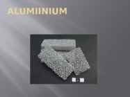
Alumiiniumi omadused Kaal - Alumiiniumi tihedus on 2,7 g/cm3, kõigest umbkaudu kolmandik terase tihedusest. Saamine - Alumiiniumi looduses ehedalt ei esine, kuigi ta on maakoores üks levinumaid elemente (massisisaldus maakoores 8,2 %, kolmas element hapniku ja räni järel). Alumiiniumi saadakse maakidest (boksiit) elektrometallurgilisel menetlusel. Suurim alumiiniumitootja ühe elaniku kohta on maailmas Island (2001. aastal üle 900 kg metalli elaniku kohta) Rakendused - Ehedalt ja kergsulamitena konstruktsioonimaterjalina, elektrijuhtmetena, valgust ja soojuskiirgust peegeldavate katetena. Võimaliku ebasoovitava biotoime ja alumiiniumi pinna halva puhastatvuse tõttu on vähenenud alumiiniumi kasutamine köögitarvete valmistamiseks. Alumiinium asub perioodilisussüsteemis 3
Ibiza is an island in theMediterran e a n S 79 km e a off the coa st of the
Kristel Sepp TIK IB 09.10.09 "You can never go home again" "Lord of the flies" The quote "You can never go home again" is related to "Lord of the flies" in both literal and metaphorical sense. Luckily most of the boys could go home in a literal sense but unfortunately some of them were dead by the time rescuers came to save them. When boys were left on the island alone the savages inside them started to appear and there were few quite good reasons for that. The experience on the island changed all of them and when they were finally rescued everyone went home as sort of different persons. In the beginning when boys had just discovered that they are alone in this paradise island they were all innocent and longed for rescue but towards the end they gradually turned into savages who painted their faces, hunted and were willing to kill each other
Jamaica Lehasalu Andres AT112 Jamaica Jamaica is an island country situated in the Caribbean Sea, comprising the third- largest island of the Greater Antilles. The island, 10,990 square kilometres in area, lies about 145 kilometres south of Cuba, and 191 kilometres west of Hispaniola, the island containing the nation-states of Haiti and the Dominican Republic. Jamaica is the fifth- largest island country in the Caribbean. The indigenous people, the Taíno, called it Xaymacain Arawakan. meaning the "Land of Wood and Water" or the "Land of Springs". Jamaica Marcus Garvey, Father of the Back to Africa Movement and Jamaica's first National Hero. Language The official language of Jamaica is English. Jamaicans primarily speak an English- African Creole language known as Jamaican Patois, which has become known widely through the spread of Reggae music
Ursula Potivar Geography of Madagascar Topography Madagascar is an island in the Indian Ocean off the eastern coast of southern Africa, east of Mozambique. At 587,000 square kilometres, Madagascar is the world's 46th-largest country and the fourth- largest island. Madagascar can be divided into five geographical regions: the east coast, the Tsaratanana Massif, the central highlands, the west coast, and the southwest. The east coast The east coast consists of a narrow band of lowlands, formed from the sedimentation of alluvial soils and zone, composed of steep bluffs, alternating with ravines bordering an escarpment of about 500 meters in elevation. The coastline is straight, with the exception of the bay.
New Zealand New Zealand is an island country. It is in the south-western Pacific Ocean comprising two main island, North- and the South Island with lots of smaller islands. New Zealand is notable for its geographic isolation. It's about 1,600 kilometers from Australia and its closest neighbours to the north are New Caledonia, Fiji and Tonga. New Zealand's total land area is 268,021 square kilometers. The country extends more than 1600 kilometers along its main,north - north-east axis and has about 15,000 kilometers of coastline. The South Island is the largest land mass of New Zealand and is divided along its
Geography New Zealand is an island country in the Southwest Pacific Ocean. It lies about 1600 kilometres southeast of Australia, its nearest continental neighbour. New Zealand belongs to Polynesia, a large island group. The country consists of two main islands The North Island and the South Island and several dozen much smaller islands. The population is 4.1 million. New Zealand is a beautiful country of snowcapped mountains, green lowlands, beaches and many lakes and waterfalls. No place is more than 130 kilometres from the coast. Lakes, rivers, and waterfalls are found throughout New Zealand. Most of the lakes lie in the volcanic plateu of the North Island and in glacial valleys near the Southern Alps of the South Isaland
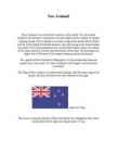
New Zealand New Zealand is on of the first countries in the world. It to be located southeast of australia.It consists of two main islands and a number of smaller outlying islands. New Zealand's two main components are the North Island and the South Island.The North Island is only half as big as the South Island, but nearly 75% of the population live on the North Island. About two-thirds of the south Island is covered with mountains. More than 220 mountains are higher than 2000 meters.The largest outlying island is Auckland. The capital of New Zealand is Wellington, it is the southermost national capital city in the world. It is New Zealand's sixth largest city behind the Auckland. The Flag of New zealand is a defaced blue Ensign with the union flag in the canton, and four red stars with white borders to the right.
Ireland Ireland is the third-largest island in Europe and the twentieth-largest island in the world. It lies to the north-west of continental Europe and is surrounded by hundreds of islands and islets. To the east of Ireland is the island of Great Britain. The Republic of Ireland covers five- sixths of the island. It is a parliamentary democracy and a republic. It is bordered to the northeast by Northern Ireland, which is a part of the United Kingdom, and is otherwise surrounded by the Atlantic Ocean: particularly, the Irish Sea to the east, St George's Channel to the southeast, and the Celtic Sea to the south. The population of Ireland is estimated to be 6.2 million. Thick woodlands covered the island until the 1600s. Today, it is the most deforested area in Europe
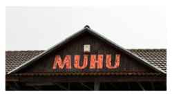
Muhu • Muhu (German: Mohn/Moon; in Estonian also called Muhumaa), is an island in the Baltic Sea. With an area of 198 km2 it is the third largest island belonging to Estonia, after Saaremaa and Hiiumaa. Together with neighbouring smaller islands of Kesselaid, Viirelaid, Võilaid and Suurlaid it forms Muhu Parish. The island has a population of 1,697 (as of 19 April 2010) and covers an area of 206.12 km2. The population density is 8.8/km2. Geography • The most important villages in Muhu are Kuivastu, Liiva and Koguva. It is linked by ferry to Virtsu in the mainland, and to Saaremaa by a causeway, the Väinatamm. In winter an ice road connects the island to the mainland. The same waters saw the Battle of Moon Sound in September–October 1917 between Russian and German naval forces
Oti Manor House Introduction Oti Manor House is the oldest baronial estate on the island of Saaremaa, Estonia, in the Baltic Sea. It was first mentioned in historical records in the year 1309. Now, the Manor offers comfortable accommodations in elegantly decorated suites and many nature tours on the island. Location Oti Manor House is located on the island of Saaremaa in Estonia in the North East of Europe. The island of Saaremaa is a 2-hour drive from the capital Tallinn, by rental car, taxi or public transport. During summer 2005, you have a possibility to reach Oti Manor by taking a flight from Finland (Helsinki Vantaa Airport) or from Sweden (Stockholm Arlanda Airport) to Kuressaare, where you can rent a car. Oti Manor is less than an hour drive from Kuressaare. HISTORY The oldest manor in Saaremaa, Oti (Peudorf in German) was privatized already in the beginning of the 14th century
Vaalapüügikomisjoni ja Euroopa Liidu kriitikast. Püütakse vaid kääbusvaala, mis ei ole ohustatud liik. 2007. aastal oli vaalapüügilimiit 1052 isendit, püüti 592 vaala. 2.osa: Islandi ndus Islandi majandus sõltub suuresti kalandusest. Kalatooted moodustavad pea poole (42%) Islandi eksporditulust ja enam kui 12% SKP-st ning pakub tööd 5% elanikkonnast. 4/5 eksporditavast kalast läheb Euroopa Liitu, millest 34% omakorda Suurbritanniasse ja 12% Hispaaniasse. Island püüab iga elaniku kohta 4 tonni kala. Kui võrrelda seda ELiga, siis seal püütakse iga elaniku kohta keskmiselt kõigest 10 kg! "Fisheries is the backbone of our economy." -endine Islandi suursaadik Stefan Haukur Johannsson Mandrilava ümber Islandi, mis on sooja Golfi hoovuse ja Arktika külma toitainete voolu kohtumispunkt, pakub väga soodsaid tingimusi erinevatele mere-elukatele ja on rikkaks püügikohaks. Peamised liigid on tursk, heeringas, meriahven,
Ireland Ireland Ireland is a country which covers about 5/6 of Ireland island. Remaining 1/6 of this island is Northern Ireland. Republic of Ireland is located to west from Great Britain. Official language in Ireland is English and Irish. There's 26 countys WebRep Üldine reiting Dublin is the capital and most populous city of Ireland The population of Ireland is approximately 6.4 million. Just under 4.6 million live in the Republic of Ireland and just under 1.8 million live in Northern Ireland Ireland history The first known settlement in Ireland began around 8000 BC,
Ireland is the third largest island in Europe. It lies in between the Atlantic Ocean and the Irish Sea. Politically it is divided into a sovereign state, the Republic of Ireland, that covers about five-sixths of the island (south, east, west and north-west), and Northern Ireland, which is part of the United Kingdom, covering the northeastern sixth of the island.[1] The name 'Ireland' derives from the name Ériu (in modern Irish, Éire) with the addition of the Germanic word 'land'. The population of the island is just under 6 million (2006); just over 4.2 million in the Republic of Ireland[2] (1.6 million in Greater Dublin[3]) and just over 1.7 million in Northern Ireland[4] (0.6 million in Greater Belfast[5])). Politics Politically, Ireland is divided into: · The Republic of Ireland, with its capital Dublin.
Ireland Ireland is a beautiful island that is washed and influenced by the Atlantic Ocean in the west.It is known for its gorgeous landscape, the green hillsides and the rocky coastline. Film-makers from all over the world have used the beautiful landscape of the island. Ireland is the third-largest island in Europe. It lies to the north-west of continental Europe. The population of Ireland is 6.2 million and there are two official languages English and Gaelic. Ireland `s capital is Dublin. The area of Ireland is 84,421 km2 Ireland is separated into two parts. The north is part of the United Kingdom, while four fifths of the island make up the Republic of Ireland, which has been an independent country since 1921. The Irish are fun-loving and friendly. They like music and humour
landscaper André Mollet. At the end of the 17th century and early 18th century were the cows in the park and could to buy fresh milk in "Lactarian". Location: The park is located in central London. This is 23 hectare large. St. James's Park is surrounded by Buckingham Palace to the west, The Mall and St. James's Palace to the North, Horse Guards to the east, and Birdcage Walk to the south. The park has a small lake, St. James's Park Lake, with two islands, West Island, and Duck Island, which is named for the lake's collection of aquatic birds. What to see and do in the park: Pelicans The first pelicans were given by a Russian ambassador in 1684. Living near Duck Island are the Park's famous resident Pelicans. Regular visitors can see the Pelicans basking on their favourite rocks and getting fed fresh fish at 2:30pm every day. There are currently five Pelicans in the Park. Horeseguards Parade
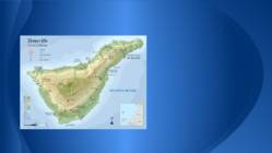
Tenerife Andres Mällo 7.a Tartu Raatuse Kool About Tenerife Largest and most populaous island of the seven Canary Islands lot of tourists World largest carnivals Two airports Santa Cruz capital of island University La Laguna El Teide Mountain Volcano Highest point Third Highest volcano Tenth highest island It remains active Teide National Park Most visited National Parks Loro Parque Located Puerto de la Cruz Paradise for parrots Opened 1972 World largest parrots collection Showes Large animal collection Orchid garden Siam Park Water park Construction Thai theme First green water park Used Sites http://en.wikipedia.org/wiki/Tenerife http://et.wikipedia.org/wiki/Tenerife http://en.wikipedia.org/wiki/Teide http://en.wikipedia.org/wiki/Loro_Parque http://en.wikipedia
Tenerife Andres Mällo 7.a Tartu Raatuse Kool About Tenerife Largest and most populaous island of the seven Canary Islands lot of tourists World largest carnivals Two airports Santa Cruz capital of island University La Laguna El Teide Mountain Volcano Highest point Third Highest volcano Tenth highest island It remains active Teide National Park Most visited National Parks Loro Parque Located Puerto de la Cruz Paradise for parrots Opened 1972 World largest parrots collection Showes Large animal collection Orchid garden Siam Park Water park Construction Thai theme First green water park Used Sites http://en.wikipedia.org/wiki/Tenerife http://et.wikipedia.org/wiki/Tenerife http://en.wikipedia.org/wiki/Teide http://en.wikipedia.org/wiki/Loro_Parque http://en.wikipedia
Ireland Position Ireland is the third largest island in Europe, and the twentieth largest island in the world. It lies to the northwest of Continental Europe and is surrounded by hundreds of islands. To the east of Ireland, separated by the Irish Sea, is the island of Great Britain. Politically, the Republic of Ireland (also known simply as Ireland) covers five sixths of the island, with Northern Ireland, part of the United Kingdom, covering the remainder in the northeast. Climate Overall, Ireland has a mild, but changeable, Oceanic climate with few extremes. The warmest recorded air temperature was 33.3 °C at Kilkenny Castle, County Kilkenny on 26 June 1887, where as the lowest recorded temperature was 19.1 °C at Markree Castle, County Sligo on 16 January 1881. Inland
Irish History Tallinn 2009 Ireland is the third-largest island in Europe, and the twentieth-largest island in the world. It lies to the north-west of continental Europe and is surrounded by hundreds of islands and islets. To the east of Ireland, separated by the Irish Sea, is the island of Great Britain. Politically, the state Ireland (described as the Republic of Ireland) covers five-sixths of the island, with Northern Ireland, part of the United Kingdom, covering the remainder in the north-east. The first settlements in Ireland date from 8000 BC. By 200 BC Celtic migration and influence had come to dominate the island. Relatively small scale settlement by both the Vikings and Normans in the Middle Ages gave way to complete English domination by the 1600s
Ireland Jaan Paljak Class 9 21.11.2011 Geography • The island of Ireland is located in the north-west of Europe, between latitudes 51° and 56° N, and longitudes 11° and 5° W. It is separated from the neighbouring island of Great Britain by the Irish Sea and the North Channel. • A ring of coastal mountains surround low plains at the centre of the island. climate The climate of Ireland can be summed up as being mild, moist and changeable with abundant rainfall and a lack of temperature extremes. The country receives generally warm summers and mild winters, and is considerably warmer than other areas on its latitude. This is due to the fact it lies in the Atlantic Ocean, and as a result is warmed by the Gulf Stream all year. tourist attractions Smarmore Castle Benburb Castle The National Galle
· Veekogud: ojad, vähem jõgesid Taimestik · Iseloomulikud taimed: puhmad, samblad, samblikud · Taimede kasvu mõjutab: · Igikelts · Madal temperatuur · Lühike vegetatsiooni periood · Juurestik pinnapealne Loomastik · 17 vaalaliiki ja mitu hülgeliiki · Linnud olulised, maismaa loomi vähe · Roomajaid ja kahepaikseid ei ole · Paljud loomad taimetoidulised · Talvel on saar elutu ja tühi Üldandmed · Pealinn: Reykjavik · Keel: Island · Valuuta: Islandi kroon Rahvastik ja asutus · Rahvaarv 332 529 · 3 in/km2 · 7,4% elanikest on välisriikidest Majandus · Põhiline tuluallikas: kalandus · Maavarad: boksiit, rauamaak · Geotermiline energia- kuumaveeallikad Majandus · Metsa Islandil pole · 78% on kasutut maad, 1% kasutatakse viljakasvatusele · Kalakasvatus, kalasööt, kalajahu koduloomadele ja lindudele Kasutatud kirjandus · https://www.reisiguru.ee/riikID/66
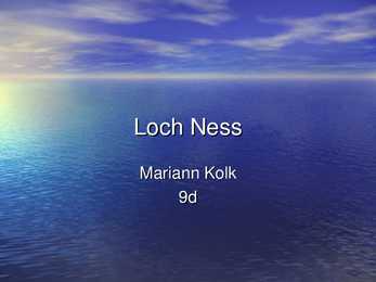
Loch Ness Mariann Kolk 9d Geographical particulars · large, deep freshwater · 37 km long · southwest from Inverness · surface area 56.4 km² · deepest point 230 m · about 10,000 years old Urquhart Castle · beside Loch Ness · the largest strongholds · majority of Loch Ness Monster sightings Cherry Island · only island on Loch Ness · artificial island · from the Iron Age The Loch Ness Marathon · an annual marathon race · along Loch Ness to Inverness · $2,500 · supports several charities · over 1,500 participants Loch Ness monster · an alleged animal · bestknown mysteries · Nessie · 60 feet long · a long tail with 4 fins and a big head · the water horse · categorized: 1. unknown species of large animals 2. mystic or paranormal 3. misidentification of known animals 4
IRELAND Ireland is a very beautiful island in the Atlantic Ocean. That lays next to Great Britain. This island is gorgeous landscape, the green hillsides and the rocky coastline. Ireland weather is influence of the Gulf Stream, there is warm and rainy through the year. The Celts inhabited the land. Ireland is separated into two parts. The north part (smaller) is part of the United Kingdom, bigger part of island makes up Republic of Ireland (independent country). The population of the Republic of Ireland is about three and half million people. There are two official language- English and Gaelic. Mostly there is used English. The Irish are know as friendly and fun-loving people. They like music and humor. In Ireland the most popular legend is about the leprechaun. He is the shoemaker of the Irish fairy kingdom. The leprechaun usually walks alone, is fun-loving and very crafty