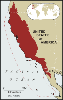
The flora of the Mediterranean Basin is dramatic. Its 22,500 endemic vascular plant species are more than four times the number found in all the rest of Europe; the hotspot also supports many endemic reptile species. As Europe's vacation destination, populations of threatened species are increasingly fragmented and isolated to make way for resort development and infrastructure. The Mediterranean monk-seal, the barbary macaque and the
Birds of paradise have also been historically traded, especially for their feathers. While West Papuans' use of the birds' feathers in cultural celebrations is part of their tradition, Europe was once the main market for the plumes, to be used for women's hats and accessories. Trade peaked in the late 19th century, when plumes from more than 50,000 birds were exported every year, generally to Paris for capes and hats. /1/ Birds of paradise continue to be smuggled out of Papua Province, Indonesia. The trade in the birds adds to the pressure they already get from continued hunting and the destruction of their habitat by logging, road construction and conversion for human use. Although banned by the Indonesian government since 1990, trading in the feathers of the birds of paradise is still ongoing./5/ Vital waterways for people and wildlife Home to crocodiles, freshwater sharks, barramundi and hundreds of other fish species,
Typical animals are: eagles, black bears, coyotes, deers and chipmunks. Land. Across the country Canadians experience many different landscapes from rolling plains and mountains to the cold tundra of the north. Geographically, Canada can be divided into five major regions: the Pacific Region, the Prairie Provinces, Central Canada, the Atlantic Provinces and the North. The Pacific Region includes Canada's westernmost province British Columbia. The region is known for its mild coastal climate, its forests and its spectacular mountains, including the famous Rockies which are also the youngest and highest mountains in Canada. British Columbia is in the landform region called the Western Cordillera (system of mountain ranges). Between the mountain ranges are areas of high plateaus and deep trenches. Since the landscape is very rugged, most people live in the south and near the coast. Vancouver and Victoria are the
Topic Canada Tallinn English College 2006 1. Introduction If you had to use two words to describe Canada, they might be large and diverse. Canada is the second largest country in the world with a territory of about 10 million square kilometers and it is bordered by three oceans: the Arctic, the Pacific and the Atlantic Oceans. The population of Canada is about 31 million people. About 77% of the people live in cities which lie in a band about 100 miles wide above the border of the United States. The capital of Canada is Ottawa. Other large cities are Montreal, Toronto, Vancouver, Winnipeg and Quebec. 2. Geographical position Canada is a huge country in the continent of North America. It is bordered with the Atlantic Ocean in the east, the Pacific Ocean in the west, the United States of America in the south and the Arctic Ocean in the north. Canada is a vast country, with a territory of 3.8 million square
economy. In the French-speaking region of Quebec, the city of Montreal has become one of the nation's centers for high-technology firms. This includes a large number of computer software companies. There is also a large industrial base which includes companies that produce pharmaceuticals, aerospace products, and telecommunications equipment. Ontario is the nation's main industrial center. About half of all Canadian manufactured goods are produced in Ontario. The province is second only to Michigan as the largest producer of automobiles and car parts in North America. Ottawa, the nation's capital, is located in Ontario. Other industries include chemicals, aerospace, steel, and food processing. The plains (or prairie) provinces of Alberta, Manitoba, and Saskatchewan are the home to four-fifths of Canada's agricultural lands. They are also the home to the majority of mining and fuel production. Alberta itself provides 90 percent of
notably spruces and firs. Around the Great Lakes and New England are mixed forests of pines, maples, elms, birches, oaks and beeches. Along the Gulf of Mexico grow magnolia, red and black gum, cypress and mangrove. Geographical Regions The territory of the United can be divided into eight regions: 1) New England; 2) the Mid-Atlantic region; 3) the South; 4) the Midwest; 5) the Southwest; 6) the Rocky Mountain region; 7) the Pacific Northwest and Alaska; 8) California and Hawaii. New England is highly industrial, but it also has many fields, woods and small towns. New England is the part of the United States that is most like "old" England. It includes six states: Maine, New Hampshire, Vermont, Massachusetts, Rhode Island, and Connecticut. The Mid-Atlantic region plays an important role in the United States. Its cities include Washington D. C., the nation's capital, and New York City, the nation's financial centre. The Mid-Atlantic region is densely populated
Arizona Arizona is a state in the southwestern region of the United States. It is also part of the Western United States and of the Mountain West states. It is the sixth largest and the 14th most populous of the 50 states. Its capital and largest city is Phoenix. Arizona is one of the Four Corners states. It borders with New Mexiko, Utah, Nevada, California, and Mexico, and one point in common with the southwestern corner of Colorado. Climate Southern Arizona is known for its desert climate, with very hot summers and mild winters. Northern Arizonafeatures forests of pine, Douglas fir, and spruce trees; the Colorado Plateau; some mountain ranges (such as the San Francisco Mountains); as well as large, deep canyons, with much more moderate summer temperatures and significant winter snowfalls
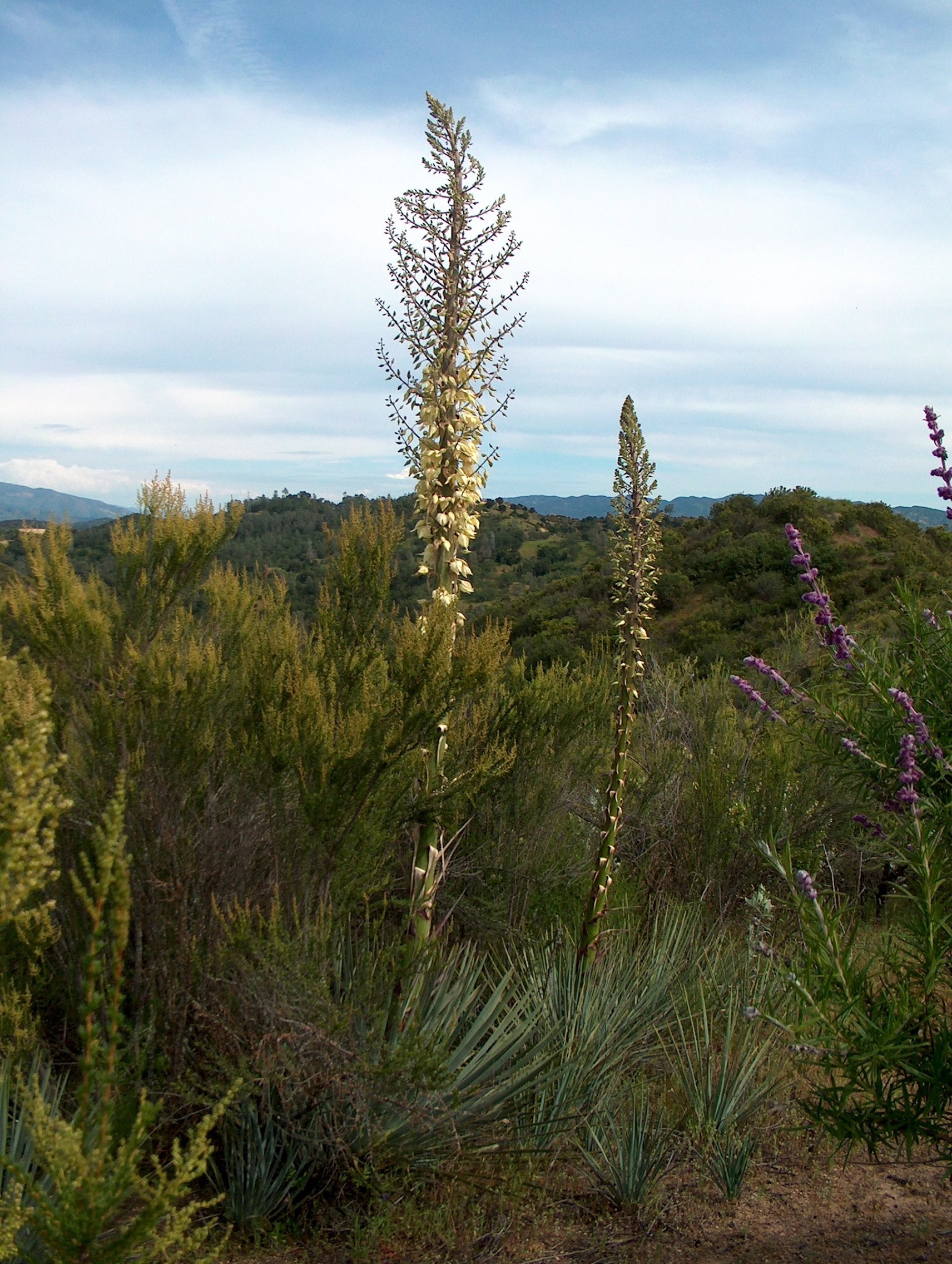
MIINA HÄRMA GYMNASIUM Deserts Saudi-Arabia Tartu 2007 Deserts In geography, a desert is a landscape form or region that receives very little precipitation. Generally, deserts are defined as areas that receive an average annual precipitation of less than 250 mm (10 inches). Deserts cover at least one-fourth of the Earth's land surface. Desert biomes can be classified according to several characteristics. There are four major types of deserts: · Hot and dry · Semiarid · Coastal · Cold Location The four major North American deserts of hot and dry deserts are the Chihuahuan, Sonoran, Mojave and Great Basin. Others outside the U.S. include the Southern Asian realm, Neotropical (South and Central America), Ethiopian (Africa) and Australian. The major deserts of semiarid deserts include the sagebrush of Utah, Montana and Great Basin. They also include the Nearc


Kõik kommentaarid