........... 8 Population and Ethnicity..............................................................................................9 3 Introduction The official name of the country is the United Kingdom. The United Kingdom is an island country. It consists of the island of Great Britain and Northern Ireland. Great Britain can be divided into three parts England, Wales and Scotland. Each of them has their own capital city. Glasgow in Scotland, Cardiff in Wales and London in England. The country is situated in the north-western Europe. The territory of the United Kingdom is about 244,000 square kilometres and about 60 million people live there. The UK contains a number of small islands. The largest islands that belong to the United Kingdom are the Isle of Man in the Irish Sea and the Isle of Wight which lies off of England's southern coast
The United Kingdom The United Kingdom consists of England, Scotland, Wales and North Ireland and it is situated in the Atlantic Ocean near the mainland of Europe. The population of the UK is 58.6 million and area is 244,110 sq km. Britain has a temperate humid climate. Its characteristic features are mild winters, warm summer, no temperature extremes, abundant rain all year round and frequent changes of weather. The mild climate is partly due to the warm Gulf Stream and partly to the south westerly winds
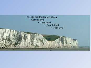
relations and defence. Great Britain Across / 'krs / risti, läbi, põiki Locality / l'kælt / asukoht, paikkond Inland body / 'nlænd 'bd / sisemaine osa Inlet / 'nlet / merekäär, laht Headland / 'hedlnd / neem Scour / 'ska / küürima Foreshore / 'f:: / tõusu ja mõõna vaheline rand Recreational / rekr'enl / lõõgastumis-, vabaaja- Scenery / 'si:nr / maastik Juxtaposition / dkstpz'in / kõrvuti asetsev GB consists of England, Scotland and Wales. GB is only a dot on the world map. It offers a great variety and scenic contrasts are often within easy reach. The coastline is washed by the tidal system twice a day. Britain´s speciality is the man-made scenery. Each part of the country has its peculiar geographical features. England Indented / n'dentd / sakiline Estuary / 'estjr / suudmelaht
4 million. The capital is London. Other biggest cities include Birmingham, Bristol, Portsmouth, Glasgow and Swansea. English is the main language of Great Britain, but Welsh is officially recognized in Wales and Gaelic in Scotland. 2. Geographical position The British Isles is the geographical term for a group of about 5000 islands off the coast of mainland Europe. The largest island is Great Britain, which is also the largest island in Europe. It consists of England, Wales and Scotland. The next largest island is Ireland, which is made up of Northern Ireland and the Irish Republic. Britain and Northern Island together form the United Kingdom. When referring to Britain or Great Britain in everyday life, the names are used to mean the United Kingdom. The English Channel (and best known: the Strait of Dover) separate Britain from mainland Europe and its closest neighboring country France. 3. History
Scotland ! Scotland (Gaelic: Alba) is a country in northwest Europe that occupies the northern third of the island of Great Britain. It is part of the United Kingdom, and shares a land border to the south with England. It is bounded by the North Sea to the east, the Atlantic Ocean to the north and west, and the North Channel and Irish Sea to the southwest. In addition to the mainland, Scotland consists of over 790 islands including the Northern Isles and the Hebrides. Edinburgh, the country's capital and second largest city, is one of Europe's largest financial centres. It was the hub of the Scottish Enlightenment of the 18th century, which saw Scotland become one of the commercial,
laws to a new province of the Roman Empire and started to build good roads. Officials were appointed (governors, procurators to collect taxes, look after the estates and mines and se that the gold, silver, iron and lead were exported back to Rome). Introduced schools,a new language Latin, large farms (villas), baths. In AD 410 they had to leave . roman occupation lasted nearly 400 years. They left behind very little. Roman province of Britannia covered most of present-day England and Wales. 4. Latin influence on English *The influence of Latin is noticeable also in the names of European cities: the Latin noun colonia (settlement, colony) may be found in numerous place-names: Lincoln, Colchester, Cologne ; from Latin word castrum (military camp) were derived English affixes -chester and -castle: Manchester, Lancaster, Newcastle; Latin word portus (seaport) in Portsmouth *-tor - person, doer, masculine form
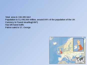
1) General facts The UK: * the United Kingdom of Great Britain and Northern Ireland was formed in 1801 * it covers 243,610 sq km * everybody from the UK is called British * the capital city is London * is made up of four constituent countries: England, Scotland, Wales and Northern Ireland which in turn are divided into counties * the flag is called the Union Jack which is a combination of the flags of England, Scotland and Northern Ireland * the population is about 60,000,000 people, the population density is 242 people/sq km * its coasts are washed by the Atlantic Ocean, the North Sea, the English Channel, the Celtic Sea, Saint George's Channel, and the Irish Sea. It is linked to France by the Channel Tunnel * the United Kingdom is a constitutional monarchy. The current monarch is Queen Elizabeth II, who is also the Queen and Head of State of fifteen other Commonwealth Realms, such as
The well-preserved village of Skara Brae on the Mainland of Orkney dates from this period. Neolithic habitation, burial and ritual sites are particularly common and well-preserved in the Northern Isles and Western Isles, where lack of trees led to most structures being built of local stone. Roman influence The written protohistory of Scotland began with the arrival of the Roman Empire in southern and central Great Britain, when the Romans occupied what is now England and Wales, administering it as a province called Britannia. Roman invasions and occupations of southern Scotland were a series of brief interludes. In 834 AD the general Gnaeus Julius Agricola defeated the Caledonians at the battle of Mons Graupius, and Roman forts were briefly set along the Gask Ridge close to the Highland line (none are known to have been constructed beyond that line). Three years after the battle the Roman armies had withdrawn to the Southern Uplands


Kõik kommentaarid