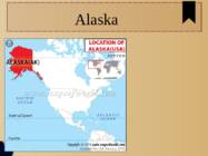
2011 Table of Contents 1.Alaska info...................................3.lk 2.Geography.....................................4.lk 3.Natural features......................5.lk 4.Climate...........................................6.lk 5.Pictures.........................................7.lk 6.Used Sources..............................8.lk Alaska info Alaska is the largest state in the United States by area. It is situated in the northwest extremity of the North American continent, with Canada to the east, the Arctic Ocean to the north, and the Pacific Ocean to the west and south, with Russia further west across the Bering Strait. Alaska is the least densely populated state of the U.S. 2 Alaska was purchased from Russia on March 30, 1867, for $7.2 million at approximately two cents per acre
Alaska General information Area 1,717,854 km² (1st) Capital Juneau Population - 731,449 (47th) Native people Numerous tribes The Inuit people (eskimos) The Aleut people The Alutiiq people Colonisation Russians - 17th century Name origin Alaska (Russian) Alakshak (Aleutan) Peninsula Nicknames The Last Frontier Land of the Midnight Sun State of Alaska 1959 Symbols Flag - Seal - Symbols 2 Bird - Willow Ptarmigan Dog - Alaskan Malamute Sport Dog Mushing Head of state Governor Sean Parnell (2009..) Republican Geography Coastline 800km East Canada West the Bering Sea North Arctic Ocean South Pacific Ocean Mountains 50 peaks higher than 3.6km Mount McKinley 6.2km Mount Saint Elias 5.5km
Area: Total 9,826,630 km2 (by CIA World Factbook) Currency: United States dollar ($) Motto: In God We Trust Anthem: "The Star-Spangled Banner" Flag Names: The Stars and Stripes, Old Glory, The Starry Banner Seal: Great Seal of the United States Flag Seal Geography America consists of 50 states. 48 of them are on North American continent and 2 of them (Alaska and Hawaii) are separated. Alaska is separated by Canada and Hawaii lies in the Pacific Ocean. America shares borders with Canada, Mexico and Russia. According to different sources American landmass is from 9,522,055 km2 to 9,826,630 km2 which makes it the third or fourth largest country in the world. America is surrounded by three oceans Pacific Ocean, Atlantic Ocean and Arctic Ocean. It's also bounded with Gulf of Mexico and Bering Strait. The highest point in America is Mount McKinley (6,194 m) in Alaska
The U.S. economy is the world's largest national economy Click to edit Master text styles Second level Third level Fourth level Fifth level Nature America consists of 50 states. 48 of them are on North American continent and 2 of them (Alaska and Hawaii) are separated. Alaska is separated by Canada and Hawaii lies in the Pacific Ocean. America shares borders with Canada, Mexico and Russia. America is surrounded by three oceans Pacific Ocean, Atlantic Ocean and Arctic Ocean. It's also bounded with Gulf of Mexico and Bering Strait. The highest point in America is Mount McKinley (6,194 m) in Alaska. The lowest point is Death Valley which lies 86 metres below sea level. The Great Basin Desert is the largest desert in America.
Indeed, all the Canadians except the Indians and Eskimos, are really immigrants or their descendants. Canada is politically a young country. In 1967 the people celebrated its first century of independence. It was on the first of July, 1967, that four provinces of British North America joined together and formed the Dominion of Canada. Geographical facts. Canada occupies the northern portion of North America. It shares land borders with the United States to the south and with Alaska to the northwest. It shares territorial water boundaries with the United States, Greenland to the northeast, and Saint-Pierre and Miquelon (an overseas community of France) to the southeast. Canada stretches from the Atlantic Ocean in the east to the Pacific Ocean in the west. To the north lies the Arctic Ocean. The most densely populated part of the country is the Quebec City-Windsor Corridor in the east. This part is thinly soiled, rich in minerals, and dotted with lakes
the world's largest producer of zinc and uranium and a world leader in many other natural resources such as gold, nickel, aluminium, and lead; many, if not most, towns in the northern part of the country, where agriculture is difficult, exist because of a nearby mine or source of timber. 7. Climate Because of its great latitudinal extent, Canada has a wide variety of climates. Ocean currents play an important role, with both the warm waters of the Gulf Stream in the Atlantic and the Alaska Current in the Pacific affecting climate. Average winter and summer high temperatures across Canada range depending on the location. Winters can be harsh in many regions of the country, particularly in the Prairie provinces, where daily average temperatures are near -15 °, but can drop below -40 °C with severe wind chills. Coastal British Columbia is an exception and enjoys a temperate climate with a mild and rainy winter.
C. Other big and famous cities are New York, Los Angeles, Houston, Chicago and Las Vegas. The national anthem of the United States is "The Star-Spangled Banner", with lyrics written in 1814 by Francis Scott Key. There are 6 time zones. From east to west they are: Eastern Standard Time, which is 5 hours behind Greenwich Time, Central Standard Time, Mountain Standard Time, which is 7 hours behind Greenwich Time, Pacific Standard Time. Alaska and Hawaii have their own time zones: Alaska Standard Time and Hawaii Standard Time. Geographical Position The USA lies in the Northern Hemisphere in North America. It covers a big part of the continent and is also the third largest country in the world. The country consists of 50 states, but two of them lie separately. One of them is Alaska, which is near the Arctic Circle. And the other state is Hawaii, which is a group of island is the Pacific Ocean. The USA shares the border with Canada in the north and Mexico in the south
In spite of this, in recent years there is a strong movement in Frenchspeaking Quebec to become an independent country. 8. Natives Canada is a relatively young country whose recorded history goes back less than 500 years. When the European settlers arrived, Canada was already populated by a diverse range of aboriginal peoples, Indians and Inuit, who are thought to have arrived from Asia 10 3000 years ago by crossing a land bridge formed between Siberia and Alaska during the last ice age. It is believed that the ancestors of Canadian Inuit were inland hunters who adapted their lifestyle to new conditions. Some of them lived near the coast and began to hunt seals and walruses. Their main diet consisted of marine mammals and fish. Others never went to sea but hunted game in nearby areas. The traditional dwelling where the Inuit lived used to be an igloo, which is a domeshaped house built out of blocks of ice


Kõik kommentaarid